


w111
Monterey's
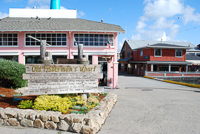
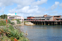
Fisherman's Wharf
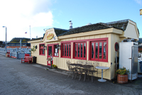
Monterey actually enjoys two wharves. The Fisherman’s Wharf that draws most people’s attention juts into the bay from near the front of the historic Custom House and the adjacent Custom House Plaza. It’s a delightfully sensual jumble of sights, smells, and sounds that draws hundreds of people each day, especially during summer. Food is one of the real attractions here. In front of many of the small stands, proprietors offer free samples of their delicious clam chowders, while fresh fish and crab lie atop mounds of ice, and slabs of salmon smoke slowly on open smoke pits. There are several restaurants, all offering good food, along with great views of the harbor. Many people who wander onto the wharf simply pick and choose samplings of shrimp and crab cocktails, fried calamari, or the plethora of other seafood that tempts the palate. And there’s always the gift shops filled with T-shirts and postcards and stores selling taffy, ice cream, and chocolate-covered frozen bananas.
The wharf is also the place to catch fish. Not from the tourist wharf itself, but from any one of several fishing boats that leave early each morning, weather permitting. The fishing can be excellent for halibut, cod, salmon, sea bass, or other species of game fish, either in the bay or in the open waters of the Pacific Ocean. It’s always enjoyable to watch the gulls and brown pelicans (Pelecanus occidentalis) that swoop in, looking for free handouts around the fish cleaning dock. They’re often joined by one or more California sea lions (Zalophus californicus) also willing to fight for chunks of discarded fish entrails. For those not inclined to catch fish, boats also head out several times each day on whale-watching trips. During January and February the most sighted subjects are gray whales (Eschrichtius robustus), which are heading south to their birthing grounds. Summer brings the giant blue whales (Balanenoptera musculus) into the bay, along with huge schools of dolphins (Delphinus delphis) and occasional pods of orcas or killer whales (Orcinus orca). Whale-watching boats, often for reasons of time, seldom venture out beyond the relatively sheltered waters of the bay, but even here, anyone prone to motion sickness should take appropriate precautions.
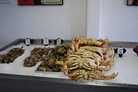
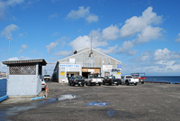
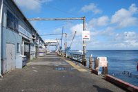
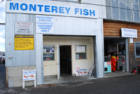
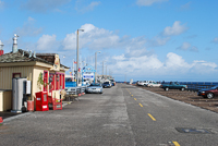
For a little closer look at the commercial fishing boats unloading their catches, the commercial wharf and marina, located a few hundred yards east of Fisherman’s Wharf, is the place to go. Gulls, pelicans, and sea lions shadow the fishing boats as they motor into the wharf and tie-off. Their fish cargoes are sorted and packed with ice into large transport containers. Unknown to most people, this is also the best place for the public to purchase whole fish by the pound. The prices are the lowest you’ll find anywhere around, and the fish come really fresh, sometimes still wriggling. The sellers will clean and fillet the fish for you for a small additional fee. Or, if you have a fishing pole and tackle, you can try your luck from the commercial wharf, as many people do. It’s not a bad way to spend a couple of hours.
Directions: Both wharves and the marina are located near the Custom House Plaza in Monterey, paralleling Del Monte Avenue in Monterey. There are two well-marked entrances.
Activities: Fishing, shopping, eating, whale watching.
Facilities: Restaurants, gift shops, fresh fish sales, fishing and whale-watching trips.
Dates: Open daily.
Fees: Both wharves are free. The commercial fishing wharf has metered parking. The adjacent Monterey Fisherman’s Wharf does not allow vehicles, but there’s an adjacent parking lot.
Copyright 2015 by Publishing Syndicate, all rights reserved.
For permission to reprint text or photos contact Ken@PublishingSyndicate.com
w112
Avila Beach
Choosing to depart the main highways and cities for a little side road exploration can generally reveal wonderful surprises. Such is the case with Avila Beach, tucked into the hills along the coast at the end of Avila Beach Drive, not far from Highway 1. This small coastal town, situated at the tip of the upside down fishhook-shaped San Luis Obispo Bay, provides a sheltered cove for a popular pier and swimming beach. The wide sand beach is a very busy place, as is Port San Luis, which is located at the end of the road. The pier, in addition to having a restaurant, offers an opportunity to board a sport fishing boat and see whales from December through March, or during summer, lets fishing enthusiasts regularly catch rock cod, halibut, and albacore. For those not willing to fish for their fish, either live or freshly caught fish can be purchased at the pier. There are a few restaurants, a bait shop, and a boat launch.
For more information: There is no central contact point for Avila Beach. Contact the San Luis Obispo Countywide Lodging Information Line, phone (800) 634-1414.
Copyright 2015 by Publishing Syndicate, all rights reserved.
For permission to reprint text or photos contact Ken@PublishingSyndicate.com
Photos coming
soon
w113
Big Basin
Redwoods
Deep in the Santa Cruz Mountains, stands of giant coast redwoods (Sequoia sempervirens) still survive in great profusion. While the ancient trees are found still farther south in a few protected canyons along the Big Sur coast, Big Basin Redwoods State Park is where extensive stands of 2,000-year-old trees still remain. Efforts to save the trees began in earnest in 1900, when photographer Andrew P. Hill and other early conservationists founded the Sempervirens Club, which led to the creation of Big Basin Redwoods State Park two years later, when 3,900 acres were transferred from private ownership to the State of California. Since its inauguration as California’s first state park (if Yosemite’s temporary late nineteenth century state ownership is disregarded), Big Basin has grown extensively, now approaching 20,000 acres. Sempervirns Fund, the modern successor to the Sempervirns Club, along with numerous other private individuals and public benefit organizations, have added property over the past 100 years.
What all of these people have seen worthy to protect is the result of the Pacific and North American plates’ movement that created a complex assortment of geologic actions. The oldest rocks in Big Basin are found only in the eastern portion of the park. The 70 million- to 90 million-year-old quartz diorite found here originated perhaps a few thousand miles to the south and moved north with the shifting plates. Sandstone, mudstone, siltstone, and shale, all of which range in age from 50 million years old to as young as 8 million years, are the other rock types found within most of the Waddell Creek watershed.
Some 60 million years ago a surge of uplifting began along the Zayante fault that lies within the park. South of the fault, erosion slowly cut the deep gorge that follows Waddell and other creeks, while to the north, eroded sedimentary deposits accumulated behind the rising rock dam. The result was a flat valley floor where park headquarters is now located.
The deep alluvial soils that lie beneath park headquarters, combined with rainfall that averages over 3 feet a year or more in the park, provide an ideal growing medium for coast redwoods. Some of the largest trees in the park are located here, alongside the turbid waters of meandering Opal Creek. But the towering redwoods aren’t the only attraction in Big Basin. Wildlife abounds, although many of the animals are more secretive than most visitors would like.
One of the most common creatures is the 6-inch long, slimy banana slug (Ariolimax columbianus). These greenish yellow mollusks are common, especially where the ground is wet. Once actively fed by both park employees and visitors, the Columbian black-tailed deer (Odocoileus hemionus columbianus) has become less common in the heavy-use areas of the park, but it is still seen. Fortunately for the deer, such harmfulfeeding practices have long since ended. Several species of chipmunks (Tamias spp.), raccoons (Procyon lotor), and chickarees or the Douglas squirrel (Tamiasciurus douglasii), are relatively common.
It’s not uncommon to see California quail (Callipepla californica) running across trails and disappearing into shrubs such as salmon berry (Rubus spectabilis) and huckleberry (Vaccinium spp.). It’s less common, but much more exciting, to see a pileated woodpecker (Dryocopus pileatus), whose jackhammer-sounding pecking near the tops of trees echoes through the forest. This largest of the woodpeckers is easily identified by its size, up to 19 inches tall, with a flaming red crest. Then there’s the common steller’s jay (Cyanocditta stelleri), the ever-present camp robber. In fact, anywhere people linger with food, a raucous crowd of squawking steller’s jays is likely to appear suddenly. And along the creeks the American dipper or water ouzel (Cinclus mexicanus) is a fascinating bird to watch as it dives underwater and swims, searching for small fish or invertebrates.
The Big Basin Redwoods State Park visitor center is located in a 1936-era, Civilian Conservation Corps-constructed log lodge that also serves as the park headquarters and campground registration office. Exhibits tell the story of the area’s early history, including the threat of logging that pushed so many people into creating the park and saving the ancient trees. Gunpowder was also made in the Big Basin area. The very hard wood of the madrone (Arbutus menziesii), a tree common on the warmer ridges in the park and surrounding mountains and easy to identify by its peeling, reddish-brown bark, made excellent charcoal, required for the manufacture of gunpowder. A large diorama shows the early days of the park when cottages and other structures, such as a barber shop, a post office, tennis courts, and a dance floor were available for visitors’ use. It also was a time when campsites cost $.50 per night. Park brochures, hiking maps, and a few nature books are available for sale, and there are chairs set around the old stone fireplace, offering a comfortable place to sit and read or take a break.
A small museum housing a room full of exhibits that tell the natural history story of the park is located across the road from the visitor center, around behind the park store and gift shop. Wander in and take a few minutes to read some of the text on the exhibit panels. Most is fairly short, but each will let you in on the secrets of banana slugs, geology, marbled murrelets (Brachyramphus marmoratus), and the redwoods. There’s a small back room that’s filled with specimens of dozens of the kinds of animals found in the park, all stuffed, except for the snakes that are displayed in long glass tubes filled with a liquid preservative.
Directions: Travel north from Highway 1 at Santa Cruz via Highway 9 to Boulder Creek. At the stop sign, turn left onto Highway 236 and drive about 10 miles to the park.
Activities: Camping, hiking, picnicking.
Facilities: Campground, tent cabins (open-sided cabins with stoves), camp store, gift shop, visitor center, and museum.
Dates: Park is open year-round.
Fees: There is a fee for camping and day use.
Closest town: Boulder Creek, 15 miles.
For more information: Big Basin Redwoods State Park, 21600 Big Basin Way, Boulder Creek, CA 95006. Phone (831) 338-8860. For camping reservations phone (800) 444-7275.
TRAILS
There are 80 miles of trails in Big Basin Redwoods State Park, ranging from short, level walks to strenuous, multi-day hikes. Many of the trails can be reached from trailheads that begin near park headquarters. Others are accessed from other areas within the park, and a few can be reached from trailheads that begin outside the park. Dozens of combinations of loop and one-way trails are possible, depending upon the time available and the level of adventure desired.
The Redwood Trail is a short, 0.5-mile, self-guided nature trail is located across the street from park headquarters and is a great hike for families. Pick up a trail guide at the visitor center before you go. It offers brief explanations about what will be found on the walk. For example, there’s a large and very obvious redwood circle at post number one, which is a group of new trees growing from the original roots and in a circle around the slowly decaying stump of its old-growth parent tree. The remainder of the trail holds marked examples of tanbark oak (Lithocarpus densiflorus), chimney trees (which are old redwoods hollowed by lightning-caused fires that can smolder inside the trees for months), and other wonders of natural history. This trail also features one of the oldest trees in the park, estimated at 2,000 years, and the tallest tree in the park, the Mother-of-the-Forest, which stands 329 feet.
The Skyline to the Sea Trail begins in nearby Castle Rock State Park, and the 30-mile trail meanders into Big Basin near China Grade Crossing at the northwest corner of the park. It then heads southwest, and 5 miles later passes just above Opal Creek near Big Basin park headquarters. It continues southwest some 12 miles on a mostly downhill trail, finally reaching the Pacific Ocean at the Rancho del Oso Nature Center. There are several trail camps along the way for those wishing to spend a little more time enjoying the backcountry trails.
The Sunset-Berry Creek Loop Trail is not for the weak of heart or lungs or legs. This 11.5-mile hike begins on an easy uphill slope from a trailhead located just off the Redwood Trail near park headquarters, reaches the top of a ridge, then plunges about 1,200 feet down a steep canyon trail. At the bottom, the trail passes three wonderful waterfalls, the highest of which, Berry Creek Falls, plunges 60 feet. The tough part is climbing back up the ridge to the top, at Hihn Ahammond Road, before the final short hike back to the beginning of the trail at park headquarters.
While the 4 mile Sequoia Trail can simply be bypassed and some of its destinations reached more quickly by driving, hiking is a significantly more enjoyable way to go. The trail picks up near park headquarters and loops south and east, then north past the Wastahi Campground, finally reaching Sempervirens Falls. The small, but beautiful waterfall tumbles into a small pool, surrounded by redwoods and a cliff face covered with ferns. Just a couple hundred yards north of the falls is Slippery Rock and the Founders Monument that memorializes the founding of the Sempervirens Club in 1900. The trail continues north and connects with the Skyline to the Sea Trail that then leads south, returning to park headquarters.
Copyright 2015 by Publishing Syndicate, all rights reserved.
For permission to reprint text or photos contact Ken@PublishingSyndicate.com
Photos coming
soon
w114
Golf on the
Monterey Peninsula
For thousands of people each year, there is one primary activity that the Monterey Peninsula is known for, and it’s not sailing on blue water or watching beautiful sunsets. It’s playing golf. The annual AT&T ProAm, with its combination of top professional players and Hollywood and other celebrities, has certainly helped spur public awareness of some of the peninsula’s most spectacular courses. The ProAm is played on three of the most famous courses—Pebble Beach, Poppy Hills, and Spyglass Hill. Unfortunately, these particular golf courses are generally out of the range of most golfers, not in terms of difficulty (although they are extremely challenging), but in terms of price, with green fees for 18 holes hovering near the three century mark for anyone not staying in the resort’s hotel. But even with money in hand, be sure to make reservations well in advance because drop-ins don’t have much luck getting tee times. But it remains the dream of most golfers to someday play Pebble Beach, (phone 831-624-3811). Just plan ahead.
If playing golf while enjoying views of the Pacific Ocean is a personal dream, but so is coming up with the green fees to play Pebble Beach, then the best golf bargain on the Monterey Peninsula has to be Pacific Grove’s Municipal Golf Links (phone 831-648-3177). Operated by the City of Pacific Grove, the course is challenging and well-maintained, and several holes parallel the coast so that golfers get to enjoy ocean views similar to those at Pebble Beach, and contend with the sometimes challenging winds. The biggest difference is that this golf course’s green fees give you change from a fifty-dollar bill.
Other courses that are very popular include the Del Monte Golf Course (phone 831-373-2700) in Monterey, established in 1897, making it the oldest course on the peninsula, and Rancho Cañada (phone 831-624-0111) located just off Carmel Valley Road, with its two reasonably priced championship courses. In the general vicinity of Monterey there are a couple of dozen other quality courses with varying green fees. During summer advance reservations are always a good idea.
For more information: There’s no centralized center for golfing information. It is best to contact the Monterey Peninsula Visitors and Convention Bureau, phone (831) 648-5358.
Copyright 2015 by Publishing Syndicate, all rights reserved.
For permission to reprint text or photos contact Ken@PublishingSyndicate.com
Photos coming
soon
w115
Hearst Castle
As William Randolph Hearst’s publishing fortune accumulated to levels most people could only dream about, his growing collection of primarily European art and art treasures also grew. While creating a repository for his art collection was certainly one of the reasons for beginning construction of what was to become commonly known as Hearst Castle, he also wanted to upgrade “camp hill” where his father had brought his family and friends on outings. After William Randolph Hearst’s mother died in 1919, he apparently began the complete transformation of “camp hill” with a simple message to his San Francisco architect: “...Miss Morgan, we are tired of camping out in the open at the ranch in San Simeon and I would like to build a little something….” What followed was 30 years of almost continuous construction and improvements to “camp hill,” which Hearst renamed La Cuesta Encantada, The Enchanted Hill.
The castle’s isolation and its grand elegance required a huge army of very skilled craftsmen and workers. Ocean steamers delivered the tons of necessary construction materials, including concrete, steel, and lumber, to the pier at San Simeon where strong backs and the underpowered trucks of the day hauled everything to the top of the 1,600-foot-high construction site, 5 miles away.
Spectacular views of the ocean and the surrounding mountains greeted Hearst’s guests as they enjoyed the 137-foot-tall, 130-room Hispano-Moresque main mansion he named Casa Grande and the guests’ houses, Casa del Mar, Casa del Monte, and Casa del Sol. Hearst’s guests were nearly always the rich and famous, especially Hollywood stars. They weren’t restricted to the hilltop. Hearst encouraged horseback riding excursions to the distant parts of the 75,000 acres of his ranch, just a portion of the 250,000 acres that his father, George Hearst, originally owned.
Some of what Hearst used to decorate his 137-acre hilltop home—the paintings and tapestries, the furniture, the vases and lamps—are originals purchased over a lifetime of collecting from around the world. Others, such as many of the sculptures, are pieces that he recruited the best sculptors of the day to create for him.
Hearst Castle is one of those places that is impossible to adequately describe in a few paragraphs. Its elaborately tiled outdoor and indoor swimming pools, the multilevel gardens filled with thousands of flowers, the eclectic collection of art pieces such as the beautiful French Gothic mantel, Spanish choir stalls, Flemish tapestries, bronze, gold, and silver sculptures, and fantasy beds require more than words. They must be seen.
Directions: Hearst San Simeon State Historical Monument is located about 30 miles north of Morro Bay, just off Highway 1, in the small village of San Simeon.
Activities: The only way to see Hearst Castle is to join a guided tour, which includes a bus ride to the top of the hill where the home is located.
Facilities: The tour staging area has food service, a large gift shop, a theater, and a visitor center. The visitor center provides a glimpse into the history of Hearst Castle and the man who built it. It also provides a close-up look at many of the artifacts, the research that went into developing the exhibits, and some of the work required to restore many of Hearst’s treasures.
Dates: The castle is open daily, except Thanksgiving, Christmas, and New Year’s Day.
Fees: There is a moderate fee for each of the four tours.
Closest town: Cambria, 8 miles south.
For more information: Reservations are almost always required. For tour reservations, phone (800) 444-4445.
Copyright 2015 by Publishing Syndicate, all rights reserved.
For permission to reprint text or photos contact Ken@PublishingSyndicate.com
Photos coming
soon
w116
Los Osos Oaks
State Reserve
If a single tree had to be identified with California’s central coast, the coast live oak (Quercus agrifolia) would be at the top of any list. It lacks the grand size and graceful symmetry of some of its cousins, such as the valley oak (Quercus lobata). Instead, as if serving as inspiration to the many artists and other creative minds who have settled California’s coast, the multi-trunked coast live oaks appear to grow in conformance to the whims and wishes of the coastal winds and the contours of the rolling hills they inhabit. Let the fog blow through this oak woodland, and walking the trails of this small but important reserve can become a surreal adventure. But even on clear days, it’s an extraordinary experience.
There is a figure-eight-shaped trail in the preserve that begins at the small parking lot. From the grasslands near the parking lot, the trail crosses a bridge over a small stream and leads directly into a grove of coast live oaks. Going left quickly leads to the riparian habitat along perennial Los Osos Creek. Since this 85-acre site sees few people and offers several different biotic communities, wildlife is almost always present. Whether or not it will allow itself to be seen is another matter. Fortunately, western rattlesnakes (Crotalus viridis) tend to shy away from people, and southern alligator lizards (Gerrhonotus multicarinatus) also prefer to escape from humans. The seemingly ever-present western fence lizard (Sceloporous occidentalis), with its blue sides and belly, will likely be the most visible reptile.
The most obvious residents here are birds. Nuttall’s woodpeckers (Picoides nuttallii) and California thrashers (Toxostoma redivivum) are generally around, with many smaller birds keeping to the underbrush. The occasional tall pile of sticks is home to the 12- to 18-inch-long dusky-footed woodrat (Neotoma fuscipes). Gray foxes (Urocyon cinereoargenteus) and bobcats (Felis rufus) occasionally slip-up and get caught in plain view near the trail.
The trail passes through 30-foot-tall oaks, many contorted by the salt air and winds that kill new buds, creating the limbs’ stubby, twisted shapes. Continue up a small hill and the trees are still as old as those first encountered, but now they are only from 6 feet to perhaps 10 feet tall. These dwarf trees simply occupy an environment that offers poorer soil with fewer nutrients, less water, and more wind, all of which combine to significantly stunt their growth.
Continue beyond the oaks whose acidic leaves create soil conditions that most understory plants cannot endure and the woodland is replaced by the drier chaparral. Here is where black sage (Salvia mellifera) and bush monkey flower (Mimulus sp.) are joined by splashes of spring wildflowers such as mock heather and western peony (Paeonia brownii).
Directions: Take Los Osos Valley Road for about 1 mile southwest of the town of Los Osos, south of Morro Bay.
Activities: Hiking, bird-watching.
Facilities: None.
Dates: Open daily.
Fees: None.
Closest town: Los Osos.
For more information: California Department of Parks and Recreation, San Luis Obispo Coast District Office, 3220 South Higuera Street, Suite 311, San Luis Obispo, CA 93401. Phone (805) 528-0513.
Copyright 2015 by Publishing Syndicate, all rights reserved.
For permission to reprint text or photos contact Ken@PublishingSyndicate.com
w117
Los Padres
National Forest
Stretching for over 200 miles, the Los Padres National Forest covers nearly 2 million acres of California’s Central Coast. It’s a rugged and beautiful country, much of it accessible only on foot. Within the forest lands, there is a 19.5-mile stretch of the Big Sur River and 33 miles of Sisquoc Creek that have been designated as Wild Rivers under the Wild and Scenic Rivers Act.
Hiking for any distance within either Los Padres National Forest or the contiguous Ventana Wilderness provides ample opportunities to experience the real Big Sur, the portion that motorists who focus primarily on the ocean and coastal cliffs never experience: the rugged, steep-sided mountains that seem always to climb higher and offer still more spectacular views, the cascading rivers and creeks that fight their way through narrow, rocky gorges, and unimaginable views of spring wildflowers that stretch to the distant ocean. The only things missing are the discordant sounds of modern civilization, which quickly become only a distant memory.
Many plants grow in their own little niches. Small, isolated groves of redwoods thrive in narrow, protected river canyons, while Ponderosa pine (Pinus ponderosa) and bristlecone fir, also known as the Santa Lucia fir (Abies bracata), grow on the drier slopes. Valley oaks (Quercus lobata) replace the shorter coast live oaks (Quercus agrifolia), and cottonwoods (Populus spp.) join willows (Salix spp.) in the riparian areas. Coastal wildflowers cover the open fields, with the purple hues of lupine (Lupinus sp.) and the golden yellow of California poppies (Eschscholtzia californica) being prominent.
The Ventana Wilderness, along with nine other designated wilderness areas, lies within the Los Padres National Forest, its 167,000 acres adding a higher level of protection and another reason to explore this part of the Santa Lucia Mountain Range.
While there are many popular trailheads popular with both day-hikers and backpackers, the Pine Ridge Trail entrance at the Big Sur Station, located just 0.25 mile north of Pfeiffer Big Sur State Park, is one of the most frequently used accesses. Wilderness permits and maps are available, as is parking in a lot that is patrolled. One of the real reasons this is such a popular jumping-off point is that it’s about an 11 mile hike from here to the hot spring near Sykes Campground. The hot spring is about 0.25 mile downriver from the campground area, on the south side of the Big Sur River. Its waters hover around 100 degrees Fahrenheit, but the area can occasionally become a bit overused because it is so popular.
Directions: A primary trailhead is located at the far end of the Big Sur Station parking lot, 0.25 mile south of the entrance to Pfeiffer Big Sur State Park, just off Highway 1. Trail maps and information are available daily at the visitor center.
Activities: Camping, hiking.
Facilities: None inside the forest or wilderness area.
Dates: The National Forest and Wilderness are open daily.
Fees: There is a small, daily parking fee for leaving vehicles in the Big Sur Station parking lot.
Closest town: Carmel, 26 miles north.
For more information: For general information contact the U.S. Forest Service’s Goleta office (phone 831-683-6711); the King City office (phone 831-385-5434); or the Big Sur Station (phone 831-667-2315).
Copyright 2015 by Publishing Syndicate, all rights reserved.
For permission to reprint text or photos contact Ken@PublishingSyndicate.com
w118
MONTAÑA DE ORO
STATE PARK
It takes a bit of out-of-the-way driving to get here, but the rewards are worth the effort. It’s also quickly evident that those people who would like to eliminate the tall and aromatic eucalyptus trees that some enterprising souls introduced into California from Australia in the nineteenth century have far to go. The narrow road passes through several groves of the trees, which emit a toxin from their leaves that pretty much eliminates most understory plants that might provide any competition. Unfortunately, with all the native plants go all the native animals that depend on them for food and shelter. What results is a relatively open forest filled with a single plant species.
As you emerge from the eucalyptus groves, the park opens onto a marine terrace rich with native coastal scrub. During spring, wildflowers, such as sticky monkey flower and California poppies, splash the hillsides with gold, helping the park live up to its translated name: Mountain of Gold. To the west, often not more than a few hundred yards from the entry road, waves crash against the rocky cliffs and wash across the intermittent sandy beaches tucked between the extended fingers of land. While the road that leads into the park winds about 7 miles and finally dead-ends near the south boundary, there’s an intricate system of trails, many of which are open to equestrians, that pass along the cliff tops, across the coastal dunes, and to the tops of the nearby peaks, such as 1,649-foot-high Alan Peak.
Like much of coastal California, at least the southern half of the state, Spain’s intrusion into this new land marked the end for the Native Americans. In 1769, Don Gaspar de Portolá’s expedition to establish Spain’s missions and presidios marked the end for the Chumash. It is estimated that as many as 30,000 Chumash lived in small villages spread from Morro Bay to as far south as Malibu. They had the ability to survive nature for thousands of years, but European diseases decimated their numbers.
By the late nineteenth century, dairy operations were the economic mainstay for the Americans who now controlled the land. One of those owners, Alexander Hazard, in a failed experiment to meet the lumber needs of the nearby growing communities, planted eucalyptus trees. His dairy operations proved much more successful. Most of the early dairy buildings were destroyed in 1947, when a grass fire swept up the coast from Diablo Canyon.
Exploring the park offers an opportunity to see firsthand the power of nature. Following millions of years of uplifting, tilting, and periodic seawater inundation, much of the park’s geology is quite visible. The popular beach at Spooner’s Cove is surrounded by rocky cliffs that show the power and stresses created by two great tectonic plates moving against one another. Tremendous pressures raised the area’s predominant rock, Monterey shale, from its more humble beginnings as mudstone from the ancient sea floor to the surface. The mudstone, a mixture of mud and sand, combined with the leftovers of dead ocean organisms, solidified into thick layers of diatomite, clay porcellanite, dolomite, and chert. The cliffs both north and south of Spooner’s Cover offer excellent examples of Monterey shale. The evidence of the receding ocean and the uplifted landmass can be seen along the trail to the top of Valencia Peak (1,347 feet). From points along the trail, the marine terraces to the south that once served as ancient beaches also become visible.
The park also includes Morro Dunes Natural Preserve, the prominent sandspit that rises as much as 85 feet and extends from the south end of the Morro Bay tidal flats, northward toward Morro Rock and separates the bay from the ocean.
When the park’s 8,000 acres and its 7 miles of shore became a state park in 1965, the name that its last private owner gave to it, stayed, Montaña de Oro. One of the few remaining structures, the Spooner Ranch house (another early owner), is now a visitor center that’s operated primarily by volunteers. It’s located about 4 miles into the park.
Directions: Montaña de Oro State Park is located just southwest of the town of Los Osos on Pecho Valley Road, which dead-ends in the park.
Activities: Hiking, horseback riding, mountain biking, fishing, beachcombing, camping, picnicking.
Facilities: There are 50 primitive campsites plus the equestrian camp area, which has two group sites and three individual sites. There is also a small visitor center.
Dates: The park is open daily, the visitor center periodically.
Fees: There is a small camping fee.
Closest town: Los Osos, 7 miles.
For more information: Montana de Oro State Park, Pecho Valley Road, Los Osos, CA 93402, or California Department of Parks and Recreation, San Luis Obispo Coast District Office, 3220 South Higuera Street, Suite 311, San Luis Obispo, CA 93401. Phone (805) 549-3312, (805) 528-0513 or (805) 772-7434. www.parks.ca.gov
Copyright 2015 by Publishing Syndicate, all rights reserved.
For permission to reprint text or photos contact Ken@PublishingSyndicate.com
w119
Morro Bay State Park
Besides being the largest town on Estero Bay, Morro Bay (the water portion) has the distinction of being a bay that lies within a bay. Morro Bay lies within Estero Bay and is nearly landlocked by a long sandspit that ends near Morro Rock. Morro Rock, the area’s most prominent landmark, is one of several ancient, volcanic hills that rise in a southeastward line beginning inland and extending into the ocean. These andesitic plugs, of which Morro Rock is the most spectacular, are composed of primarily dacite porphyry with crystallized quartz, black hexagonal plates of biotite, and white orthoclase.
Even on clear days, a shroud of fog can cling to the top of Morro Rock. Since its discovery in 1542 by Juan Cabrillo, the 23-million-year-old Morro Rock has been a maritime milepost. Cabrillo named the 580-foot-tall andesite outcropping “Morro” because he thought it resembled a Moorish turban. Today, Morro Rock is a protected State Historic Landmark, but such reverence for this special geologic landmark has not always been popular. Beginning in about 1880, tons of rock were blasted away from Morro Rock and transported by boat to nearby Avila Bay for construction of its breakwater. The quarry operation continued until 1963, when conservationists, concerned for Morro Rock’s protection, finally helped get the operation shut down.
Morro Rock is off limits to people, partly as a result of too many overly adventurous folks getting in trouble while climbing on its steep ledges, but primarily because it serves as a nesting site for a pair of peregrine falcons. While sighting the sleek hunters is always possible, it is generally much easier to see some of the other nesting birds around Morro Bay.
But it takes a walk back about 140 million years in time to know how Morro Rock was created and to understand why such a large variety of minerals is common in the area, including the iron-stained dunes, volcanic rhyolite tuff, and the sedimentary chert. From 100 to 140 million years ago, the area now occupied by Morro Bay was a shallow depression that subsequently filled with seawater, which was followed by rocks, sand, and other detritus. With the nearly constant moving of California’s tectonic plates, the pressures created deep beneath the surface formed cracks in the overlying rock that lay beneath the sea. Ultimately, molten rock was forced upward as the faulting and folding continued and the sea retreated. Then, 20 million years ago (middle Miocene) the subsurface pressures became so great that volcanoes erupted, again pushing molten rock to the surface.
From 1 million to 4 million years ago, strong compressive forces folded and elevated all of the older rock formations during what became the Central Coast’s most intensive mountain-building period. The seas that had flooded the area once again withdrew, and many of the southern coastal ranges were formed.
As much as the changing geology, the fluctuating sea level has had significant impacts on the Morro Bay region. Beginning 20,000 years ago, melting ice caps and glaciers began to cause the ocean to rise. At that time the beach was about 4 miles farther offshore. Twelve thousand years later, about 8,000 years ago, the ocean water was only about 5 feet to 10 feet shallower than it is in today’s estuary.
Morro Bay’s estuary covers 2,300 acres of mud flats, tidal wetlands, and open water, all of which serves as a repository and mixing bowl for the fresh water that flows from the nearly 50,000 acres of surrounding watershed. It also holds one of the least human-disturbed saltwater marshes in California, providing a rich mix of habitats that support one of the most diverse collections of bird species in the country. Because of its key position within the Pacific Flyway and its habitat offerings, some 250 species of birds have been observed here. They include birds that make the area their permanent home and many more that migrate through, often including threatened and endangered bird species such as the peregrine falcon (Falco peregrinus), black brant (Branta bernicla), brown pelican (Pelecanus occidentalis), and snowy plover (Charadruis alexandrinus).
Morro Bay State Park, in addition to having a very popular campground and one of the very few golf courses owned by California State Parks, is home to a wonderful museum that sits at the edge of an uplifted segment of sedimentary chert overlooking the bay’s shoreline. It also offers a view across the tidal flats that reach the harbor, its boats, and beyond to Morro Rock. Inside the museum is a wonderful collection of both natural and cultural history exhibits that provide a thorough introduction to the area. There are numerous birds and fish (all stuffed), along with a small gift shop featuring primarily nature-related publications. Docents at the museum also lead tours and offer other interpretive programs.
Just a short walk from Morro Bay State Park’s natural history museum is a grove of eucalyptus trees that has been adopted by great blue herons as their primary nesting site in the area. Some of the nests are 4 feet across, added to each year by the returning herons. While great blue herons are year-round residents at Morro Bay, the best time to see them in their treetop nests is beginning in February when their courtship rituals begin, through spring and summer when the surviving broods finally leave their nests.
Directions: The town of Morro Bay is adjacent to Highway 1, also known as the Obispo. Morro Bay State Park and its adjoining estuary can most easily be reached by following the signs and driving just past Morro Bay on Highway 1 and turning south onto South Bay Boulevard. Then go right onto State Park Road into the park.
Activities: Bird-watching, golf, boating, fishing, camping, picnicking.
Facilities: Museum, golf course, campground, picnic area, marina, and golf course.
Dates: The park is open daily; the museum is open daily, except Thanksgiving, Christmas, and New Year’s Day.
Fees: There’s a small fee at the museum and moderate camping fees. Reservations are generally required during summer. Phone (800) 444-7275. There is no fee for day use in the remainder of the park.
Closest town: Morro Bay.
For more information: Contact Morro Bay State Park, State Park Road, Morro Bay, CA 93442. Phone (805) 772-2560 or (805) 772-2694. www.parks.ca.gov
Copyright 2015 by Publishing Syndicate, all rights reserved.
For permission to reprint text or photos contact Ken@PublishingSyndicate.com
w120
Oceano Dunes
State Vehicular Rec Area
Oceano Dunes sits near the center of a stretch of dunes that begins near the town of Pismo Beach, includes Pismo State Beach, and continues south to near Point Sal. The sand, originally washed down from the mountains by the nearby Santa Maria River and other smaller creeks and waterways, is pushed ashore by wave action, then blown inland into the high dunes by the often-strong prevailing winds. But these particular dunes are a wide-open playground for off-road enthusiasts. Here, dune buggies, quadrunners, and a few vehicles that don’t look like anything that would ever be seen on a city street, blast their way over the high dunes and across the open beach sands.
This is also the place to come for cheap beach camping. Summer weekends can bring several hundred tents, motorhomes, and trailers set up just above the expected high tide line. The owners of the trailers and motorhomes set up cardboard and push sand up to the bottoms of their vehicles to keep the wind from blowing through. Barbecues and beach fires are everywhere. The only problem is expecting that the quiet slap of waves and the occasional squawks of birds will be the only nighttime sounds. The sound of revving engines is often more noticeable.
Like dunes along several other areas of California’s coast, the dunes here also serve as nesting areas for the threatened snowy plover and the endangered California least tern. Surprisingly, their nesting success has been extremely good in the off-highway vehicle area. During the March-through-September breeding and fledging season, their nesting sites are fenced for protection from beach goers and sand-thrashing off-highway vehicle tires.
Other areas of Oceano Dunes are set aside as preserves where native dune plants such as arroyo willow (Salix lasiolepis) and California sagebrush (Artemisia californica) thrive in the seemingly hostile dune environment. A couple of rare dune plants, surf thistle (Cirsium rhothophilum) and giant coreopsis (Coreopsis gigantea) also grow in portions of the dunes.
Directions: Oceano Dunes State Vehicular Recreation Area can be reached via either Grand Avenue or Pier Avenue in the City of Grover Beach.
Activities: Off-highway vehicle use, fishing, camping, picnicking, swimming.
Facilities: Seasonal quadrunner rental in the park. In town, full facilities.
Dates: Open daily.
Fees: Small vehicle fee for day-use and camping.
Closest town: Pismo Beach and City of Grover Beach
For more information: Oceano Dunes SVRA, 576 Camino Mercado, Arroyo Grande, CA 93420. For recorded information, phone (805) 473-7223 or (805) 489-2684. www.parks.ca.gov
Copyright 2015 by Publishing Syndicate, all rights reserved.
For permission to reprint text or photos contact Ken@PublishingSyndicate.com
Publishing Syndicate
PO Box 607 Orangevale CA 95662
Ken@PublishingSyndicate.com
Copyright 2010-2016 by Publishing Syndicate: All rights reserved