
w151
Marin Headlands
From a distance the Marin Headlands and the lands behind them appear as reddish-brown hills, essentially devoid of plant life, except for a few small pockets of green. Nothing could be farther from the truth. The headlands’ geology is laid open for inspection and that story helps explain its modern appearance. The Marin Headlands block began its existence 100 million years ago in the depths of the Pacific Ocean, far to the south. It has slowly moved to its present location, sliding along the San Andreas fault.
At the north end of the Golden Gate Bridge from San Francisco, take the first exit, which swings under the freeway and back onto the west side of the bridge onto Conzieman Road. There’s a pullout at Battery Spencer and additional pullouts farther down the road that offer spectacular views back across the Golden Gate toward San Francisco, at least on clear, fogless days.
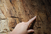
Check the roadcuts or hike down to Rodeo Cove or Tennessee Cove and look closely at the reddish rock formations. Through a hand lens or strong magnifier, the remnants of small, one-celled organisms that lived in the ancient ocean are visible. These radiolarians, now transformed into radiolarian chert, were originally laid down with layers of equally ancient mud, but over millions of years have been severely contorted by tremendous pressures and movement. Over the past several thousand years, the chert cliffs have been broken, eroded, and constantly reformed by the unending crash of waves. One roadcut along Conzeiman Road, west from the Battery Spencer overlook, has a wonderful example of relatively rare ribbon chert, easily recognized by its thin, ribbon-like strands of twisted and contorted rock.
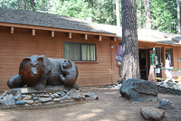
Conzeiman Road, from near the long-abandoned Battery 129, becomes one-way. Continue ahead and the road winds around past batteries Wallace and Mendell, which are also long-abandoned coastal defenses. The road finally leads to the old Fort Berry church, which has been transformed into a visitor center. It’s the perfect place to get maps and books about the area’s natural and cultural history, along with ranger- and docent-led hike information.
An interesting leftover from the early days of the Cold War is the closed Nike missile site. It’s only one of the many visual reminders of the army’s long presence on the headlands and the evolution of weapons, from nineteenth century smooth-bore cannons to World War II’s 16-inch guns and anti-aircraft weapons and finally to the underground Nike missiles of the Cold War. Each weapon system significantly extended the range that attacking enemy ships or aircraft could be engaged and destroyed. Today, guided tours of the site are available, including a demonstration alert that rolls and lifts one of the disarmed and unfueled missiles into firing position.
Over many years, ranchers and the army built small dams in headland streambeds, which created lagoons by joining small natural pools and ponds. The lagoons have become important habitat for numerous species of animals. Near the visitor center, Rodeo Lagoon is the largest of the water impoundments. There’s a trail around the lagoon, which is mostly fresh water, except when high waves occasionally wash over the sand barrier that separates it from the ocean. Within Rodeo Lagoon’s slightly saline waters lives the endangered tidewater goby (Eucyclogobius newberryi), which is only about 1 inch long. During spring and summer, most of the ponds are impossible to get close to because of the heavy growth of alders (Alnus rhombifolia), arroyo willows (Salix lasiolepis), and the ever-present cattails (Typha latifolia) and sedges (Carex sp.).
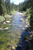
Some of the best hiking is along the trails that follow the main waterways, Tennessee Creek and Rodeo Creek. Here, the presence of water in a relatively dry land, especially during California’s rainless summers, supports a large variety of plant life. The profusion of vegetation along the creeks and on the surrounding hillsides provides cover and food for dozens of animal and insect species. Butterflies are a bright addition to the spring wildflowers that cover the landscape. Orange sulfers (Colias eurytheme) are attracted to yellow mustard, swallowtails favor lupine and fennel, and the endangered mission blue butterfly (Icaricia icarioides missionensis) searches for lupine.
Brewer’s blackbirds (Euphaus cyanocephalus) and sparrows favor the thick creekside vegetation, while brown towhees (Pipilo fuscus) and wrentits (Chamaea fasciata) are more likely to be seen in the coastal scrub. Hawks almost always soar overhead or sit on fence or power poles, especially during the fall migration. The always-present and seemingly ominous (but environmentally important) turkey vulture (Cathartes aura) uses its 6-foot wingspan to soar effortlessly on the thermals, while depending upon its keen eyesight to locate dead animals on which to feed.
From the visitor center at Fort Barry, pick up Bunker Road to exit the park. The road winds through more of the open country, finally reaching a one-way tunnel controlled by a signal light that allows alternating traffic to pass.
Directions: Marin Headlands lie on the north side of the Golden Gate Bridge, west of US 101. The easiest access is from Conzeiman Road, the first exit after crossing the Golden Gate Bridge, heading north.
Activities: Hiking, camping, picnicking, fishing.
Facilities: Visitor center.
Dates: Fort Berry Visitor Center is open daily.
Fees: None.
Closest town: Sausalito, 2 miles.
For more information: National Park Service, Fort Mason, San Francisco, CA 94123. Phone (415) 331-1540.
TRAILS
There are dozens of miles of trails that lace the Marin Headlands and offer spectacular views of San Francisco Bay, the city beyond, and the Pacific Ocean. They also provide opportunities to explore deep canyons and hidden ponds. It is best to pick up a trail map from any of the visitor centers and dress for quickly changing weather conditions any month of the year.
Miwok Trail: Approximately 0.75-mile of trail follows the north shore of Rodeo Lagoon, beginning on the north side of Rodeo Creek, near the Visitor Center at Fort Berry. It connects with another trail that continues around the sand barrier separating the Pacific Ocean from Rodeo Lagoon, passing the old Nike missile site, and finally returning to near the visitor center. The Miwok Trail actually meanders north about 15 miles, ending in Mount Tamalpais State Park and connecting with the Redwood Creek Trail near Muir Woods Road.
Bobcat Trail: The trail picks up from the east end of the Miwok trail, about 0.3 mile northeast of the Fort Barry visitor center and continues on the south side of Rodeo Creek approximately 3.2 miles, heading up into the hills. It connects with several other trails, including the Oakwood Trail, S.C.A. Trail, and a 1.5-mile spur trail to the Hawk backpack camping area.
Point Bonita Trail: From the parking area just past Battery Wallace, it’s just over 1 mile out to the Point Bonita Lighthouse, which is open on weekends during the summer season.
Copyright 2015 by Publishing Syndicate, all rights reserved.
For permission to reprint text or photos contact Ken@PublishingSyndicate.com
w152
Muir Woods
National Monument
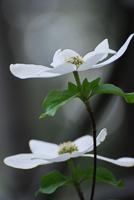
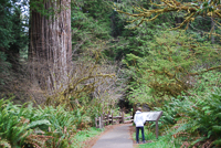
This relatively small, 560-acre park is very popular with summer tourists, especially those driving from San Francisco, who want to experience a redwood forest. Anytime of the year is a good time to visit, with spring bringing its profusion of wildflowers, including the large, white blooms of the California buckeye tree (Aesculus californica). It’s always nice to see the showy leaves of the bigleaf maple (Acer macrophyllum) open in spring because it is a reminder that in the fall they will add wonderful splashes of brilliant yellow to the forest.
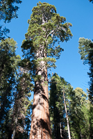
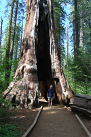
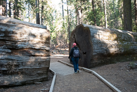
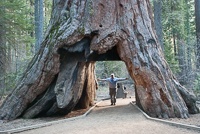
What the park is best known for is its redwoods. The largest trees, both in height and diameter, grow in the Cathedral and Bohemian groves. At 14 feet across, 250 feet tall, and 1,000 years old, they are impressive, but are only babies compared with their cousins in the redwood groves farther north in Humboldt County.
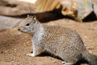
Among the redwoods, Douglas fir, and other trees, many animals find homes, although, except for chipmunks and squirrels, few are seen by visitors. Black-tailed mule deer (Odocoileus hemionus) and spotted owls (Strix occidentalis) are rarely seen, while numerous species of butterflies, including migrating monarchs (Danaus plexippus) and the acmon blue butterfly (Icaricia acmon) are much more numerous and visible.
The national monument was created in 1905, when Congressman William Kent and his wife Elizabeth purchased the property because it contained some of the last remaining uncut old-growth redwoods in the Bay Area. They paid $45,000 for the original 295 acres, then donated the land to the federal government in order to assure its continued protection from logging. In 1908, President Theodore Roosevelt declared the property a national monument and wanted to name it after Kent. Kent had another idea, preferring that it bear the name of one of the country’s leading preservationists of the time, John Muir.
On summer weekends, when up to 10,000 people may visit the park in a single day, it’s good to get here early because parking is limited. The small parking lot and the roadside shoulders fill quickly. There are no picnicking or camping facilities in the park.
Directions: After crossing the Golden Gate Bridge heading north from San Francisco on US 101, take the Highway 1 Exit and continue north on Highway 1. Turn right on the Muir Woods road and drive about 3 miles to the park entrance. The roads to the park are steep and winding. Vehicles over 35 feet long are prohibited.
Activities: Hiking, bird-watching.
Facilities: Visitor center, paved walking trail.
Dates: Open daily.
Fees: There is a small entry fee.
Closest town: Mill Valley, 3 miles.
For more information: Muir Woods National Monument, Mill Valley, CA 94941. Phone (415) 388-2595.
Copyright 2015 by Publishing Syndicate, all rights reserved.
For permission to reprint text or photos contact Ken@PublishingSyndicate.com
w153
Calaveras Big Trees
State Park
Copyright 2015 by Publishing Syndicate, all rights reserved.
For permission to reprint text or photos contact Ken@PublishingSyndicate.com
w154
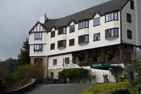
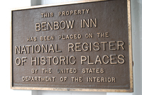
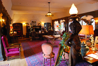
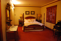
Benbow Inn
ena Lighthouse, phone (707) 882-2777.
www.parks.ca.gov
Copyright 2015 by Publishing Syndicate, all rights reserved.
For permission to reprint text or photos contact Ken@PublishingSyndicate.com
w155
Point Arena Lighthouse
Copyright 2015 by Publishing Syndicate, all rights reserved.
For permission to reprint text or photos contact Ken@PublishingSyndicate.com
w156
Point Reyes
National Seashore
Miwok Indians were the first to inhabit this land, probably attracted by the abundant food supplies and moderate climate. The first hint that their idyllic life was going to change came in 1579, when Francis Drake, seeking new lands for England’s Queen Elizabeth I, sailed his ship, the Golden Hind, into Drakes Estero, where he stayed for more than a month making repairs to his ship. The friendly Miwoks provided additional food to the English crew. During their stay, his crew had opportunities to explore the area, discovering a rich land that certainly reminded some of them of home. Before continuing on his around-the-world journey, Drake named the land Nova Albion, or New England.
Although a few other maritime explorers either passed by or landed near Point Reyes, including Don Sebastian Vizcaino in 1603, it took nearly 200 more years before there was any serious attempt to settle these lands. By the time the Americans had won Point Reyes and the rest of California from Mexico, who had taken it from Spain, the Miwok had disappeared from the land. During Mexico’s control, three men, collectively known as the Lords of Point Reyes, controlled the peninsula through land grants. Soon after it came under American control, a San Francisco law firm obtained the property and divided it into a series of ranches for beef and dairy cattle. Cattle continue to graze throughout the peninsula grasslands today.
For first-time visitors, the Bear Valley Visitor Center is the best place to begin. It’s located just a few hundred yards down Bear Valley Road, off Highway 1 in the community of Olema. The visitor center, besides offering maps, camping permits, a museum, and bookshop, serves as a starting point for numerous trails that reach all parts of Point Reyes.
With so many working ranches still on the Point Reyes Peninsula, Pierce Point Ranch offers a chance to see what went into a historic dairy operation. The ranch offers an opportunity to see a turn-of-the-century ranch house and many of the outbuildings needed for the dairy operation, including the milking barns where the cows were herded each day. Interpretive panels explain the dairy operation and the incredible attention that was paid to cleanliness. After all, the Pierce Point Ranch produced some of the finest butter and other dairy products for markets in San Francisco and beyond. The ranch is at the end of Pierce Point Road, which connects with Sir Francis Drake Boulevard, about 7 miles from the Bear Valley Visitor Center.
As the park’s Pierce Point Road nears the Pierce Point Ranch, it passes through the Tule Elk Reserve. Within the reserve, tule elk (Cervus canadensis nannodes) graze and bed down on the open grasslands. Before nineteenth century meat hunters decimated their population, thousands of elk once roamed these hills. Today, a program is in place to restore tule elk to the open lands of Point Reyes National Seashore, although they are being restricted to this small part of the park so they don’t compete with the cattle ranches still operating here. Do not approach the elk. They are wild animals and can be very dangerous.
Directions: To reach the Bear Valley Visitor Center, take Highway 1 to Olema. Turn west on Bear Valley Road and drive about 1 mile to the entrance road.
Activities: Hiking, camping, fishing, bird-watching, beachcombing.
Facilities: Visitor centers, historic buildings. Camping in the park is limited to four, hike-in campgrounds. There is no car camping in the park. Permits are required to use the hike-in campgrounds and may be obtained at the Bear Valley Visitor Center. Reservations are suggested due to the popularity of camping at Point Reyes. Phone (415) 663-8054, Monday through Friday, or make reservations in person at the Bear Valley Visitor Center, seven days a week. Reservation requests may also be faxed, (415) 663-1597.
Dates: Park is open daily. Hours vary for visitor centers and historic buildings.
Fees: There is a fee for camping.
Closest town: Olema, 1 mile.
For more information: Point Reyes National Seashore, Point Reyes Station, CA 94956-9799. Phone (415) 663-1092.
Copyright 2015 by Publishing Syndicate, all rights reserved.
For permission to reprint text or photos contact Ken@PublishingSyndicate.com
w157
Prairie Creek Redwoods
State Park
Years ago, a new freeway bypass diverted large trucks and fast-driving travelers off of the original, narrow and twisting two-lane US 101 that passed through the center of the park. The abandoned section of highway was renamed Newton B. Drury Scenic Parkway. Today, the 8-mile-long parkway allows visitors to enjoy a much slower and more appropriately paced drive through the spectacular redwood forest that borders the old highway.
Besides the redwood forest, there is one additional highlight that brings people here, many year after year—the Roosevelt elk (Cervus canadensis roosevelti). The park boasts a large population, actually several small herds, of elk. One of the easiest places to view the elk is just off the side of the parkway at the small coastal prairie, the large meadow near the entrance to one of the park’s campgrounds and the visitor center. There are almost always elk, either bedded down or munching the grass, at the edges of the open grassland and the forest border.
As with many parks, the visitor center is generally a good place to begin your visit. Prairie Creek’s visitor center, in addition to its small gift shop, which offers a great selection of publications, features numerous natural history exhibits. Here, visitors can discover the names of the many wildflowers and birds most often seen in the park.
Prairie Creek State Park has two campgrounds, the first of which is located at the south end of what is called Elk Prairie. The second is another very popular campground on Gold Bluffs Beach It requires a much more adventurous drive to find. To get there, about 3 miles north of Orick, Davison Road heads west from US 101. The first 200 yards or so, in the meadow that borders both sides of the road, is often a good place to see another of the elk herds. The road soon turns to dirt and heads upward into the forest where it winds for several miles, finally dropping down and emerging at Gold Bluffs Beach. Be warned, the road is narrow and many of the turns tight enough that vehicles over 8 feet wide and 24 feet long are prohibited. The beach campground is about 2 miles down the road, which hugs the tall bluff. Once again, elk can generally be seen near the road, often in the low dunes between the road and the beach.
Gold Bluffs Beach was aptly named. In 1851, California’s gold fever spilled over from the mines of the Sierra foothills’ Mother Lode and the Trinity River area to these bluffs. Thousands of miners flooded the area and filled the large camp that was established along the base of the bluffs. There was, and remains, gold in the bluffs, but the early miners could never manage to extract large enough quantities to make the operation economically viable. While the name of the bluffs is a reminder of its history, most first-time visitors probably believe the name is for the gold color of the bluffs’ crumbly rock.
Directions: Prairie Creek Redwoods State Park headquarters and visitor center are located about 6 miles north of Orick and the Redwood State and National Parks Visitor Center. Driving north from Orick on US 101, take the Newton B. Drury Scenic Parkway. Exit to the park headquarters.
Activities: Camping, backpacking, fishing, picnicking, hiking.
Facilities: Campground, backcountry camps, and a visitor center. There are showers in Elk Prairie Campground and solar showers in the Gold Bluffs Beach Campground.
Dates: Open daily. Camping reservations are advised during summer. Phone (800) 444-7275 to make camping reservations.
Fees: There are day-use and camping fees.
Closest town: Orick, 6 miles south.
For more information: Prairie Creek State Park, 127011 Newton B. Drury Scenic Parkway, Orick, CA 9555. Phone (707) 464-6101, ext. 5064 or ext. 5301.
TRAILS
Revelation Trail: Near the visitor center, a short, 0.3-mile, very level and easy trail loops into the redwoods. As its name implies, the trail provides revelations about the nature of the redwood forest, not only for those able to see and hear normally, but also for those who may have physical impairments. The trail’s many stopping points are designed to relate the same information to those who may be sight- or hearing-impaired.
West Ridge Trail: At 6.1 miles, this trail is the park’s longest. It follows the ridgeline that lies about 500 to 600 feet above and about 2 miles east of the ocean. The trail is only moderately difficult, remaining relatively level. It begins near the park’s visitor center and heads north, ending on Newton B. Drury Scenic Parkway. Many hikers head west just before the trail’s end and take the Butler Creek Trail (1.8 miles) down to the beach.
Fern Canyon Trail: This is one of the most popular destinations in Prairie Creek Redwoods State Park. It’s a very easy, 0.7-mile trail that begins at the north end of the Gold Bluffs Beach. The short, level walk offers a look at the geologic history of this part of the north coast. Following in the bed of the shallow creek, the trail meanders through a carved, sheer-walled canyon, revealing the nearby Klamath River’s 4 million-year-old gravel deposits.
The narrow canyon walls rise 50 feet or more and are almost completely covered by thick mats of bright green ferns. Five-finger fern (Adianthum pedatum), lady fern (Athyrium felix-femina), and sword fern (Polystichum munitum) are the most common. Orange-colored salmon berries (Rubus spectabilis) ripen during June and July, and they’re edible, but oenanthe (Oenanthe sarmontosa), which is related to carrots, is poisonous. Another berry popular with anyone hiking up the canyon is the thimbleberry (Rubus parviflorus), similar to the salmon berry. Pull the delicate red berry from its stem and it looks somewhat like a thimble. It has a very enjoyable flavor.
It seems nearly impossible that this small stream and its narrow canyon are home to so many animals, especially during late summer when the water is so shallow. Coastal cutthroat trout (Salmo clarkii clarkii) come upstream in early spring and spawn, and rare and endangered species, such as the red-legged frog (Rana aurora) and the Pacific giant salamander (Dicamptodon ensatus) also live in this moist refuge.
The trail heads upstream, then rises to the top of the bluff and loops back to the parking lot. It also connects with the James Irving Trailthat leads back across the coastal hills to the visitor center (4.2 miles). The best time to visit the Fern Canyon Trail is during the summer when the water is low and the small footbridges are in place.
Coastal Trail: Six noncontiguous sections make up the coastal trail that leads hikers through Redwood National and State Parks. It meanders, primarily along the coast, but occasionally detours inland, such as in Del Norte Coast Redwoods State Park. One of the gaps in the trail is at the mouth of the Klamath River. Hikers must turn inland to the US 101 highway bridge to get across the river. The trail begins near the end of Enderts Beach Road, just north of Del Norte Coast Redwoods State Park and ends in the south, about 1.5 miles north of Orick at US 101. Camping is allowed in the established enroute campsites on a first-come, first-served basis. Campsites on the national park lands are free. The Butler Creek primitive camp in Prairie Creek Redwoods State Park requires a permit, which can be obtained at the park office. For more information on this trail, contact Redwood National and State Parks, 1111 Second Street, Crescent City, CA 05531-4198. Phone (707) 464-6101.
Copyright 2015 by Publishing Syndicate, all rights reserved.
For permission to reprint text or photos contact Ken@PublishingSyndicate.com
w158
Redwood National Park
Redwood National Park shares many stretches of its meandering boundary with three state parks—Prairie Creek Redwoods, Del Norte Coast Redwoods, and Jedediah Smith Redwoods. Together the state and national parks form a World Heritage Site and International Biosphere Reserve, a worldwide recognition of their environmental significance.
Redwood National Park was created in 1968, several decades after the state parks were established to protect old-growth redwoods. Although much of the forest within the national park contains second-growth redwoods, the park plays a crucial role in protecting the old-growth trees that remain. The National Park Service is actively rehabilitating the logged lands, eliminating exotic plant species that have taken over many hillsides, and planting native trees such as redwoods and Douglas firs. With thousands of acres of watershed now protected from the unavoidable damage created by logging activities, especially during the early, unregulated years of the industry, flooding is much less prevalent. The ongoing efforts also help protect the stream and river gravels needed by spawning steelhead and salmon.
The coast portion of Redwood National Park is a relatively unspoiled meeting of land and sea that stretches from Stone Lagoon, directly parallel with US 101, just south of Orick, north to Crescent City. Most of it is accessible only by way of hiking trails, and there are several popular access points. One of the longest stretches of easily accessible beach is between Stone Lagoon and the Redwood Information Center in Orick. The long pull-off between the highway and the beach is a very popular day-use and overnight area for motor homes and trailers willing to forego anything in the way of amenities, except for the beautiful ocean beach view.
A walk along the beach is likely to bring sightings of numerous shorebirds chasing the ebb and flow of the slapping waves and searching the sand for insects, tiny crustaceans, and anything else that fills their bills. The rocky tidepools are a rich zone for exploration. Mussels, anemones, sea stars, and snails are among the dozens of very different animal species that are dependent upon the swirl of fresh, clean salt water for survival. Double-crested cormorants (Phalacrocorax auritus) and brown pelicans (Pelecanus occidentalis) glide low and elegantly above the water, or rise high and dive below the surface to feed.
The Prairie Creek Visitor Center, located just south of Orick, provides exhibits and a large assortment of publications about the area’s cultural and natural history, as well as maps, permits for backcountry camping, and general information about both the state and national parks found in the area.
Directions: Redwood National Park lies along various portions of US 101, between approximately Trinidad on the south and Crescent City to the north.
Activities: Hiking, backpacking, fishing, camping.
Facilities: Campgrounds, visitor center, trails.
Dates: Open daily except Thanksgiving, Christmas, and New Year’s Day.
Fees: Camping fees are charged in some areas.
Closest town: Crescent City, Orick, and Trinidad.
For more information: Redwood National and State Parks Information Center, 1111 Second Street, Crescent City, CA. 95531-4198. Phone (707) 464-6101.
TRAILS
Many of the trails in Redwood National Park, such as the Coastal Trail, connect with trails in the adjacent state parks. Bears are occasionally
encountered on the mountain trails. If you come across a bear, make plenty of noise and back away from it slowly, and it shouldn’t bother you.
DeMartin Section, Coastal Trail: This 10-mile round-trip hike heads into the backcountry, through forests of old-growth redwoods, western hemlock (Tsuga heterophylla), and Douglas fir (Pseudotsuga menziesii). While there are several grades, some relatively steep, this all-day hike is only moderately difficult. Pick up the trail south of Crescent City. Look for milepost marker 15.6 along US 101 and the signpost marked, “CT.” Park off the road.
Dolason Prairie Trail: Here’s an opportunity to see elk up close, just not too close. This moderately difficult hike weaves through prairies and oaks as it switchbacks down to Redwood Creek. You can either hike back out on the same trail, or connect with the Redwood Creek Trail that follows the canyon back toward Orick. Take Bald Hills Road about 1.5 miles north of Orick, then drive 3 miles to the Dolason Prairie picnic area, which is located past the Redwood Creek Overlook picnic area.
Lady Bird Johnson Grove Trail: This is an easy, 1-mile walk that leads through to the redwood grove where Lady Bird Johnson dedicated Redwood National Park in 1968. The grove trailhead is located on Bald Hills Road, about 3 miles east from US 101 and Orick. Phone (707) 464-6101, ext. 5265.
Redwood Creek Trail: This is a summer hike because seasonal bridges are removed during winter’s high water. It’s an 8.5-mile walk along the creek to Tall Trees Grove. While some people hike the trail in one day, others consider it much easier to backpack in. There are some restrictions, such as not camping within 0.25 mile of the Tall Trees Grove. It’s best to check at the Redwood National Park Information Center in Orick for the most updated information. Phone (707) 464-6101, ext. 5265.
Tall Trees Grove: For those unable to hike the 8.5 miles up Redwood Creek to visit the Tall Trees Grove, a few permits are issued daily for vehicle access via Bald Hills Road, off US 101 and Orick. The free permits allow vehicles access to the all Trees Access Road. From the drive-in trailhead, the Tall Trees Grove is only a 1.3-mile hike each way, with an 800-foot drop in elevation to the grove. Bald Hills Road is steep and winding, and trailers and motor homes are not allowed. Either stop in or phone the Redwood National Park Information Center in Orick for permit information. Phone (707) 464-6101, ext. 5265.
Copyright 2015 by Publishing Syndicate, all rights reserved.
For permission to reprint text or photos contact Ken@PublishingSyndicate.com
w159
Redwood Parks Roundup
Spring Silence
and Solitude
Spring is a special time in California’s north coast redwoods when lengthening days send sunshine filtering through the forest canopy illuminating surprise patches of colorful wild rhododendrons. It’s a perfect time to take a weekend or longer tour through the great forests, if you don’t mind exchanging a walk in a little rain for beautiful memories.
As more people’s free time dwindles from two-week camping vacations to long getaway weekends, traveling to the far reaches of California northern-most redwood forests is too often thought of as out of the question. Such should not be the case. Southern Californians can shave 400-plus miles and an admittedly arduous full day of driving by grabbing a cheap flight into San Francisco or Oakland and renting a car for the drive north. If time is an issue, but money isn’t, a flight into Eureka will land you much closer to the big redwoods.
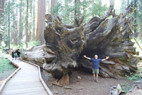
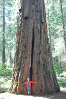
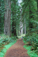
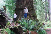
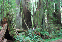
So, where to go? There are many choices. Humboldt Redwoods State Park is the premier showcase of old growth redwoods and the largest of the redwood parks. With 17,000 acres of old growth redwoods tucked into the park’s 50,000-plus acres, there are miles of trails that few people travel, especially early in the year. The park stretches from along both sides of US 101 westward into the rugged coastal mountains that help temper winter’s high winds that could topple the great giants.
Jump off the freeway on either end of the park and the old highway, now dubbed the Avenue of the Giants, meanders for more than 30 miles through the tall forests and along the winding South Fork of the Eel River. Its size, coupled with the access roads offers easy, drive-in access to some of the oldest and largest groves and equal access to trails that meander for miles through the mountains and valleys. It’s always intriguing to stand next to these great trees and wonder what the first miners in the 1850s and the settlers who followed 25 years later felt and thought as they first stared up at the trees that towered more than 300 feet over their heads. It’s likely that even the Sinkyone Indians had similar thoughts about their apparent insignificance, at least where size was considered.
The park’s Rockefeller Forest occupies a prominent part of the area’s preservation history. It’s named after John D. Rockefeller, the man who gifted $2 million in 1920 so that Save-the-Redwoods League could purchase 10,000 acres a old growth redwoods, the largest donation ever made to state parks up to that time. Within the eastern fringe of the forest, jus a few minutes’ drive from the freeway, there is a trail that will take maybe an hour to walk. It meanders through the omnipresent redwoods, small clearings filled with spring wildflowers, and toppled giants, their bark worn smooth from the footsteps of curious people who climb and walk along them.
More time? Garberville is one of the larger communities along this part of US 101. There are plenty of services here, including hotels for those not wishing to share their backsides with a sleeping back and the ground. While Humboldt Redwoods is about 6 miles north of Garberville, Sinkyone Wilderness State Park is about 22-miles and a 45-minute drive to the west.
While significantly smaller than Humboldt Redwoods, Sinkyone’s 7,000-plus acres abut more than 60,000 acres of the Kings Range National Conservation Area. The roads into the park are narrow, twisting, steep, and the last few miles turn to rutted dirt. But the trip is worth it. There are redwoods, though not as overwhelmingly impressive as Humboldt’s groves. There are also Roosevelt elk and the Pacific Ocean with its pounding waves and craggy shoreline. There’s a seasonally operated visitor center at the century-old ranch located at Needle Rock. With the exception of some minimal accommodations in one of the old buildings near the visitor center, camping is the only overnight option and that is limited to specific and small walk-in campgrounds. The popular Bear Harbor Cove sites are located near the ocean shoreline, less than a half-mile, mostly level walk from the parking area through the forest and a meadow often inhabited by elk.
Still more time? Drive north from Garberville to the three largest and most northerly redwood state parks, Del Norte Coast, Prairie Creek, and Jedediah Smith Redwoods. Del Norte is often overlooked by passing travelers heading farther north to the more often visited Prairie Creek. But the salmon and steelhead don’t bypass Del Norte. They migrate up the park’s Mill creek each year, replaying the ceremony of reproduction of their species. In the case of the salmon it’s a one way trip. The steelhead get to return again, at least if they aren’t caught by fishermen, or eaten by bears or bigger steelhead.
Del Norte is one of many redwood areas that experienced the logger’s axe and chainsaw prior to coming under the protective umbrella of state and national parks. About half of its 6,400 acres are recovering cut-over redwood forest lands. Here, alder, big leaf maple and madrone share the hillsides with second growth redwoods.
About seven miles south of Crescent City, Prairie Creek Redwoods State Park provides one of the almost certain places for seeing Roosevelt elk. But you do have to jump off the freeway and take the old highway through the park, the Newton B. Drury Scenic Parkway. A large prairie straddles the road serving as home to a herd of elk.
There’s plenty of parking along the road, with a rail fence serving to protect visitors from the huge, wild animals. And they are wild, so enjoy viewing them from a distance. There’s a visitor center and campground adjacent to the road, along with a couple short hiking trails. The visitor center is a good place to pick up books on the redwoods’ plant and animal life. On the east side of the road, about a half-mile north of the campground and visitor center, is Cal Barrel Road. Dirt and narrow in places, it’s a great place to enjoy the colorful ;pink and white plashes of wild rhododendrons.
One of the most popular areas of the park is Gold Bluffs Beach, its name being descriptive of the bluffs that face the ocean and beach area of the park. A fleeting moment of fame came to the area when gold was discovered in the bluff’s sand. The gold was quickly removed and the small community at the base of the bluffs disappeared. Today people drive the old Davidson Road, located near the south end of the park and US 101 for its several twisting miles of dirt (or mud) surface over the hills to the coast. Motorhomes and trails are not allowed. Once on the ocean side of the park, a dirt road parallels the base of the bluffs, past a small campground, passing more elk, and ending at the trailhead up fern canyon.
Fern canyon is an narrow, stream-carved gouge that meanders inland. The canyon is narrow, often not much more than 20-feet wide, but with sheer, 50-foot high walls, covered with a thick blanket of bright green ferns. The seasonal trail follows the stream bed, with several small board bridges that need to be crossed. Slipping from one of the “bridges”generally means falling a few inches and landing in a few inches of water.
Like the other redwood state parks, Jed Smith is visited primarily during summer, which is a good reason to come in spring. Few if any people are around, with the possible exception of a some locals who like to run the trails, even in the rain or fisherman chasing steelhead or salmon in the park’s Smith River. The park is named after Jedediah Smith, a mountain man considered to have been the first European to visit these redwoods. And its river is the largest in California that runs its entire length to the ocean without some kind of dam hindering its free flow. A special treat for birders, bald eagles, pileated woodpeckers and the endangered spotted owl are often seen in the park.
There are numerous other redwood parks along the north coast, each with its own claim to fame. Any one of them can become new-found favorite if you can take the time to head north and explore these ancient and venerable forests.
Copyright 2015 by Publishing Syndicate, all rights reserved.
For permission to reprint text or photos contact Ken@PublishingSyndicate.com
w160
Salt Point
State Park
The park offers a little something for just about everyone. Vegetation ranges from coastal scrub on some of the more open hillsides to forests of Bishop pine (Pinus muricata), Douglas fir, and second-growth redwoods, with scatterings of tanoak (Lithocarpus densiflora ) and madrone (Arbutus menziesii). Hike up the mountain above the coast and there’s a Pygmy forest where stunted versions of redwoods, cypress, and Bishop pine grow slowly in the nutrient-depleted hardpan soil.
The park’s coastal bluffs and isolated beaches provide great fishing and diving. One of the most popular scuba diving spots is Gerstle Cove, a portion of which is an underwater reserve. Within the reserve’s boundaries, divers and fishermen aren’t allowed to take or disturb any of the animal or plant life. But outside the underwater reserve, surf fishing and underwater spearfishing is allowed, within the bounds of fish and game regulations. During the relatively short season, the parking lot near Gerstle Cove, as well as some of the other coastal access points in the park, serve as staging areas for abalone divers.
Highway 1 runs between the coast and the higher ridgeline of the park, and there is a campground on each side. The developed portions of the park, where the campgrounds and day-use picnic areas are located, are centered near the southern end of the park. From the campgrounds, several trails meander through the park, with the most popular hike leading through the prairie to the Pygmy forest. The hike is about 2 miles long, depending on the starting point.
Directions: The park is located about 18 miles north of Jenner, on Highway 1.
Activities: Camping, hiking, scuba diving, picnicking, and fishing.
Facilities: Campground and picnic area.
Dates: Open daily.
Fees: There are camping and day-use fees. Camping reservations are recommended for summer camping. Phone (800) 444-7275.
Closest town: Jenner, 18 miles north.
For more information: Salt Point State Park, 25050 Coast Highway 1, Jenner, CA 95450 Phone (707) 847-3286 or (707) 865-2391.
Copyright 2015 by Publishing Syndicate, all rights reserved.
For permission to reprint text or photos contact Ken@PublishingSyndicate.com
Publishing Syndicate
PO Box 607 Orangevale CA 95662
Ken@PublishingSyndicate.com
Copyright 2010-2016 by Publishing Syndicate: All rights reserved