
w181
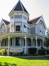
Meux Home
Fresno
Thomas Meux graduated from medical school at the age of 22 and then gained a lifetime of experience in just four years as an assistant surgeon in the Confederate Army. In 1887, driven by his wife’s poor health, Dr. Meux moved her and their three children to California, settling in the newly incorporated town of Fresno. Here, he established a medical practice and also built his family a home. It was completed in 1889 and cost $12,000, making it one of the most expensive and fanciest homes in Fresno.
Thomas Meux lived in the home until his death in 1929, at age 91. Anne, one of his daughters, remained unmarried her entire life and lived in the home for 81 years. She died in 1970 at age 85, and the city of Fresno purchased the home in 1973, with the intention of restoring the grand Victorian.
The home’s exterior is comprised of converging roof lines, punctuated by several chimneys and a five-sided tower. Different treatments have been used on the walls to enhance its Victorian-era charm. Some are horizontal clapboard, while the upper portion of the tower is covered with fancier fish scale and variegated shingles.
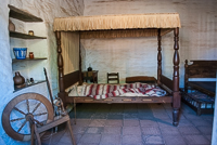
The home’s interior has been beautifully restored and is fully furnished with mostly pieces that are not original to the family, but would have been found in homes during that period. The parlor was often the main room, where most guests spent their time while visiting. In keeping with the Victorian-era hospitality, the room was very formal, and the sliding doors could close it off from the remainder of the house when needed. Some of the home and its furnishings appear to have been ordered from catalogs or purchased from stores that carried quantities of manufactured goods, rather than being custom-made. The fireplace mantel is most likely machine made. The mantel holds many small art objects, including English vases and a soapstone statue of a girl and her dog.
The parlor is where in 1906 the middle child, Mary Meux, wed her husband, Henry Barbour, who had recently arrived from New York. Dr. Meux was having a home built nearby as a wedding gift for the newlyweds, but Mary became pregnant and was due before it could be completed. She gave birth to her son in the family home, in her pink and green bedroom.
A 17th century Staffordshire tea service sits on a table and reflects one of the apparent habits of people during the late 1800s—the accompanying sugar bowl is quite large compared with the remainder of the service. Music was a part of the family’s life, as witnessed by the Edison cylinder phonograph that sits on the mahogany table.
The dining room, where the family enjoyed many formal and informal meals, still retains its original wallpaper, extraordinary considering its age. It is thought that decades of fireplace, gas fixtures, and kerosene lamp smoke has darkened the once bright, floral design paper. The beautiful mahogany sideboard is thought to be 14th century English, and the oak dining table is set, ready for the evening meal.
Dr. Meux’s wife, Mary, likely spent much time in the master bedroom, as her health was poor, and, in her later years, she became deaf and blind. But when still able to see, she enjoyed the unobstructed winter views of the snow-capped Sierra in the distance. The bedroom’s fireplace mantel is stained walnut, and like the home’s other five fireplaces, it is designed to burn coal rather than wood.
Hours: Friday through Sunday, noon to 3:30 p.m.; last tour is 3:00 p.m. Closed major holidays
Cost: Adults, $5; ages 13-17, $4; ages 5-12, $3
Location: 1007 “R” Street (corner of Tulare and “R” streets), Fresno
Phone: 559-233-8007
Website: www.meux.mus.ca.us
Copyright 2015 by Publishing Syndicate, all rights reserved.
For permission to reprint text or photos contact Ken@PublishingSyndicate.com
w182
Turtle Bay
Exploration Park
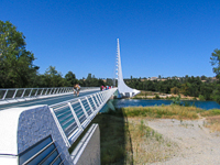
Turtle Bay, located in Redding, is a challenge to describe, since there is so much here—part visitor center and part nature center, with an anchor museum that effectively ties everything together. The beautiful Sundial Bridge, whose design is iconic of Turtle Bay and this area, stretches across the Sacramento River where its waters meander past the museum. Without a doubt, this is one educational experience that is sure to please the entire family, and the kids won’t have any idea that they’re actually visiting a museum!
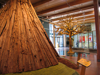
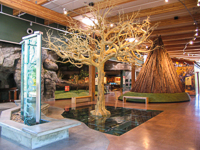
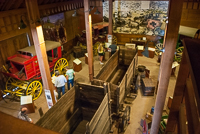
Turtle Bay’s 300 acres of opportunities for fun and learning focuses on the natural and cultural history that surrounds the adjacent Sacramento River, and the special relationships between them. Inside the main Turtle Bay Museum, which is the perfect place to start, a leafless tree stands not far from the entrance. Beneath the tree’s base, clear floor tiles provide a view of the root system, which looks remarkably similar to the tree’s upper branches. Nearby, a cedar bark lodge, its shape similar to a Plains Indian tepee, was the type of shelters that the local Wintu used.
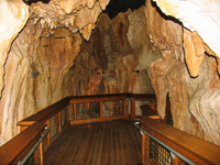
From the first floor, visitors can walk beneath the main floor and into a replica limestone cave, something found in several of California’s mountainous areas. The manufactured cave is realistic, right down to its colorful stalactites and stalagmites. It’s great for anyone too claustrophobic to explore the real thing. Two large galleries adjacent to the main museum feature special exhibits such as art shows, science exhibitions, and more on a regular basis.
The Sacramento River has always been known as a great fishing river, especially when the salmon and steelhead make their annual trips back to the gravel beds and hatcheries to start a new generation of their species. While the big fish can sometimes be seen in the river’s clear waters below the Sundial Bridge, the museum’s underwater fish viewing station offers an easier alternative. Here is an opportunity to see steelhead, salmon, striped bass, and even sturgeon up close.
For those who have a bit more scientific curiosity, the museum offers a hands-on science area—an all-time favorite for kids young and old. There are various scientific instruments available for use, such as microscopes, all prepped for viewing of everything from leaves to butterfly wings. Other kid-favored stations include a hands-on demonstration area that allows the use of 19th century tools, such as butter molds. And for the Gold Rush prospector days, there is a shelf full of supplies including tea, nails, blankets, corn meal, and more to play with. One challenge is to see how many days of supplies you can stuff into a set of saddlebags for a pretend extended trip searching for that big gold nugget!
Leave the museum and take the short walk to Paul Bunyon’s Forest Camp. Here is an opportunity to learn about what’s going on in California’s forests, while running through the major playground built to resemble a forest, an awesome tree ring maze to navigate, and several water table activities. There is a logging exhibit that, among other things, shows the tools used by today’s firefighters. There are periodic live chats with firefighters who demonstrate how the tools are used in putting out the 8000 or so wildfires that usually burn more than 300,000 acres of forest, chaparral, and grassland each year in California. There are also some wilderness creatures, all very much alive, including king snakes and gopher snakes, burrowing owls, and more. Outside, in a large demonstration area, there is an opportunity to learn about California’s water cycle, from rain to streams to dams to irrigation systems.
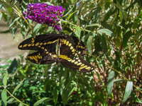
If it’s not one of those 100-plus degree summer days that the northern Sacramento Valley is noted for, strolling through the McConnell Arboretum and Gardens is a relaxing way to spend time at Turtle Bay. Mediterranean and Pacific Rim plants are clustered across the 20-acre garden site. And for those who enjoy butterflies, there is even a butterfly garden that offers a look at the plants best suited for attracting the showy creatures to home gardens.
One of the biggest changes in this part of California, besides the towns and freeways, was the construction of Shasta Dam, and the museum includes a very interesting exhibit on the dam’s construction. Outside the museum is the last remnant of the huge concrete structures that were part of the dam’s construction. Referred to as the “Monolith,” it is part of the old Kutras Aggregate Plant’s gravel-processing facility, which provided much of the gravel needed for the 6.5 million cubic yards of concrete that went into Shasta Dam. The plant closed in 1945, the same year the dam was completed.
There is still more to see at Turtle Bay, so plan on spending a good part of a day there, especially if you bring children. And if you get hungry, there is a small café with an outside seating area that overlooks the Sundial Bridge and the Sacramento River.
Hours: March through October, daily, 9 a.m. to 5 p.m.; same hours November through February, except closed on Monday
Cost: Adults, $11; 65 and older, $9; 15 and under, $6
Location: 840 Auditorium Drive, Redding
Phone: 530-243-8850
Website: www.turtlebay.org
Copyright 2015 by Publishing Syndicate, all rights reserved.
For permission to reprint text or photos contact Ken@PublishingSyndicate.com
w183
Yosemite
Nationial Park
“...the might Sierra, miles in height, in massive, tranquil grandeur, so gloriously colored and so radiant that it seemed not clothed with light, but wholly composed of it, like the wall of some celestial city.... Then it seems to me the Sierra should be called, not the Nevada or Snowy Range, but the the Range of Light.” John Muir.
It’s difficult to say which part of Yosemite National Park is most beautiful. Certainly, Yosemite Valley the most heavily visited, its neck-cramping, glacially carved granite cliffs towering high above the valley, waterfalls cascading down from the dizzying heights. It’s a 32-mile drive, in summer (winter snows close the road) up to Glacier Point, which is perched 3,200 feet above the valley below, where people and their cars are turned into scurrying ants hardly visible even through binoculars. During spring and early summer when the rivers are at their highest, stand on the bridge below Yosemite Falls, which begins its tumbling free fall from 2,425 feet above the valley floor, and you and your camera can be soaked by the spray thrown up as the tons of water pound into the great granite boulders at its base.
Thirty-five miles south of the valley is where you’ll find the largest of Yosemite’s three groves of Giant Sequoias. These remnants of an age when dinosaurs roamed free, grow to be the largest and some of the oldest living things on earth. The Mariposa Grove protects many of the grand giants, with the Grizzly Giant thought to be the oldest of all Sequoias having survived here since about 700 B.C., some 2,700 years. Two other remnant stands of Sequoias, the Tuolumne and Merced Groves, are located near Crane Flat, which is along Big Oak Flat Road along the western side of the park.
For those wishing a high adventure, a drive west along the length of Highway 120 from Highway 395 and Mono Lake, will take your breath away, both with the spectacular scenery and the thin air. Shortly after passing beautiful Tioga Lake, you’ll enter Yosemite National Park on this loftiest highway across the great Sierra, passing through the Tioga entrance at 9,945 feet above sea level. You can marvel at the fact that this roadway was originally built in 1882-83 as a mining road–long before bulldozers and heavy dump trucks had been invented. During winters of heavy snowfall, this entrance may not open until well into June.
Still heading west, in between mandatory photo stops at numerous turnouts and viewpoints, Highway 120 passes through Tuolumne Meadows. Perched at 8,600 feet, Tuolumne Meadows is the largest subalpine meadow in the Sierra, and one of a most easily accessible to those not wishing or able to hike long distances.
Yosemite’s largest campground is located in Tuolumne Meadows, but if hiking at such a high elevation is not to your liking, there are campsites also available in Yosemite Valley. The advantages of staying in the valley are always balanced by the disadvantages. Traffic jams and lots of people flock to the numerous services available here, from shops and restuarants to hotels and tent cabins. It is best and easiest because parking can be a problem during busy holiday weekends, to take advantage of the shuttle buses that can move you throughout the Valley, including trips out to Wawona and the Mariposa Grove of Giant Sequoias.
Yosemite’s shuttle buses can also drop you at several different trailheads for many of the shorter and easier (and most strenuous) hikes in the valley. It’s a short and gentle one-mile hike up to Mirror Lake, or only a half-mile round trip to the bases of Bridal Veil Fall and Lower Yosemite Fall. For the more adventurous, there’s the 3.6-mile, and 2,700 foot elevation gain, one-way hike to Upper Yosemite Fall. Or, you can try you hand at topping Half Dome, one of Yosemite’s best-known land mark granite monuments to the power of glaciers. For this one, you’d better be in great shape because it’s a 4,800 foot elevation gain that covers 17-miles round trip. Here, you’ll be using cables to pull yourself up the last part of the hike to the top of the dome. Plan on taking 10 to 12 hours to complete the trip.
One of the first things to do when you get to Yosemite Valley is to drop into the visitor center where you can pick up information about hiking trails, the bus schedule, see what some of Yosemite’s natural attractions look like, find out if bears have been a problem in the campgrounds, and pick up a list of ranger-led hikes and other programs (although some of this information will be available in handouts as you enter the park, assuming you don’t come in after the entrance station personnel have gone home for the night).
Copyright 2015 by Publishing Syndicate, all rights reserved.
For permission to reprint text or photos contact Ken@PublishingSyndicate.com
w184
Malibu Creek
State Park
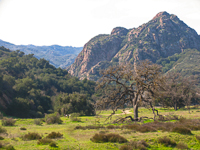
From the mind-numbing chaos of the Ventura Freeway’s several hours of “rush hour” traffic, it can be just a short drive to the quiet, calming serenity of a beautiful creek meandering through woodlands of oaks and sycamores, willows and cottonwoods. Malibu Creek State Park is one several special natural places that have been saved from the incremental creep into in Santa Monica Mountains of the mansions of the rich and famous. The result is an wonderful island of nature surrounded by cars and humanity.
Walk the quiet trails in early morning or just as the sun is setting, and crossing paths with bobcats, quail, mule deer, coyotes and raccoons is not uncommon. These and other animals have continued to thrive within the park’s 10,000 acres, which are, in turn, connected with other open and mostly undeveloped public lands, including several state parks and the Santa Monica Mountains National Recreation Area.
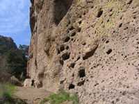
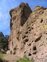
The intriguing and beautiful volcanic rock formations that create much of the park’s scenic attractiveness are leftovers from some 20-million years of conflict between the diving Pacific plate and the uplifting continental plate--and an equal amount of time being carved by wind and water. For those fascinated with California’s incredibly diverse geology, stand in Malibu Creek State Park and you’re in the state’s only east-west oriented mountains, the Transverse Range. It is also one of the state’s smallest mountain ranges.
The park’s diverse wildlife, its water and trees, and its wonderful climate are probably what attracted the Chumash Indians to the area, followed many thousands of years later by the Spanish and their missionaries. Skip another couple of hundred years and the land was passed on to ranchers and then to those who created a small, but unsuccessful resort.. Finally, it was California’s thriving movie industry that discovered the diversity of this land that would serve their myriad creative needs and lay near their Hollywood studios.
In 1941, 20th Century Fox filmed How Green Was My Valley, then decided they liked the potential settings so well that they purchased much of the land within the next few years. Hundreds of films followed, including Planet of the Apes and the television series M*A*S*H. In 1976, long before the demise of the Korean War television series set, State Parks purchased the 20th Century land, including the nearby Reagan and Hope ranches. And, while filming of major motion pictures continues on the property today, most of the park’s use is by hikers, mountain bikers, casual walkers, equestrians and people just interested in fishing, photography or watching the occasional movie being made.
If you happen to come across a movie being filmed, you’ll quickly discover that it is a slow-moving, pretty much boring process to watch. You’re better off walking over to Century Lake, much of which has silted in since the dam was built in 1901, but where a wonderful oasis for birds and waterfowl now exists. Like many areas along California’s 1,100 miles of coast, the park serves as an ideal stopover for migrating birds. Buffleheads, small, teal-sized ducks, with their prominent white chests, are fairly common around the lake and on Malibu Creek during winter, as are numerous other waterfowl.
A good first stop, following a short walk from the parking lot, is the visitor center, which sits near Malibu Creek. Originally the ranch-style house was one of the homes that was built on the property in 1926, as part of the early country club that later failed. It’s operated by docents--trained park volunteers¬¬--and includes exhibits and a small bookstore where you can obtain nature guides that can enhance your visit. There are also restrooms for those in need.
Walk across the nearby bridge that crosses the creek and turn left. Follow the trail a short distance and you’ll come upon one of the more popular spots in the park. The Rock Pool is one of those areas that dramatically displays the geologic beauty and character of the park, all reflected in the large pool created by Malibu Creek. While the Rock Pool’s beauty is both enticing and inviting, especially for photo buffs, diving and jumping from the rocky cliffs is extremely dangerous--and prohibited.
One of the often overlooked treasures of Malibu Creek State Park is the small campground. There are 62 campsites, along with flush toilets and solar-heated showers. Large groups (up to 60 people) can reserve the group camp. As in most state parks, especially during summer, reservations are strongly advised: 1-800-444-7275.
Malibu Creek State Park is located at 1925 Las Virgenes Road in Calabasas, just off the Ventura Freeway (US 101). For general park information, please call 1-818-880-0350.
Copyright 2015 by Publishing Syndicate, all rights reserved.
For permission to reprint text or photos contact Ken@PublishingSyndicate.com
w185
Old Town San Diego
State Historic Park
The Spanish influence in California, especially in Southern California, is evident nearly everywhere. Most prominent are the Spanish names of cities and streets and restaurants. Today, except for the old missions, little of California’s real Spanish and Mexican culture has been saved. There are exceptions; islands of California’s early history that have been protected and restored by the State Park System.
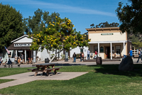
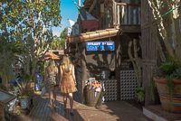
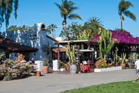
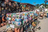
Old Town San Diego is easily the brightest and most popular of those exceptions. Although it may be difficult to transcend the time barrier to that earlier and much simpler era, especially after fighting the freeway traffic trying to get to the state historic park, visiting California’s oldest settlement is worth the effort.
More than 200 years after Captain Juan Rodriques Cabrillo claimed California for the Spanish Crown, four expeditions, headed by Gaspar de Portola met at San Diego Bay to establish a presidio. Fray Junipero Serra accompanied the expedition, establishing California’s first mission, San Diego de Alcala at San Diego Bay to establish a presidio. The padres who followed continued Father Serra’s goal of converting the Indian population to Christianity, at the cost of the Indians’ nomadic life style. Tension often increased as the Spaniards punished Indians for indiscretions the natives could not comprehend. Many more San Diego Indians, and Indians throughout California, died from European diseases from which they had no natural immunity. In 1775 the Indians revolted, attacking and burning the mission.
To further compound the problems of these early Spanish settlers, the supply routes to the more established towns in Old Mexico were never secured. In 1781, the land route was cut completely by another Indian uprising, leaving the California colonies on their own, except for the occasional ship that visited, and most of those were American traders who illegally entered Spanish territory.
Toward the end of the century, Spain attempted to improve the crumbling defensive capabilities of San Diego by repairing the adobe fortifications and increasing the garrison size. By 1800, San Diego’s Spanish population had increased to 167, which included soldiers and their families, cattle ranchers, and up to 1,500 Indians living at the mission.
Not long after Mexico won its independence, the government sought to decrease the power of the Church. Secularization forced the Missions to grant their lands to the Indians. The Indians, however, were ill-equipped to manage such undertakings and their lands where soon sold or embezzled into the hands of those who would soon control the great California ranchos.
The ranchos provided a steady trade of cattle hides and tallow or “California Banknotes” for the trading ships coming to San Diego from the eastern United States. But for many reasons, the ranchos of Southern California never prospered as did their counterparts to the north.
A few Americans, including such notables as mountain man, trapper and explorer Jedediah Smith, had traveled through Alta-California throughout the early 1800s. Generally they received poor receptions from Mexican officials, usually landing in jail for having entered the country illegally.
Mexico finally lost California when Commodore Robert Stockton arrived in San Diego with reinforcements for the Marines and sailors of the U.S. Cayne, who had first raised the U.S. flag over San Diego on July 29, 1846. The war between Mexico and the U.S. ended with the Treaty of Guadalupe Hidalgo, which was signed in February, 1848. Under the treaty, the United States gained Texas, New Mexico and California.
San Diego continued to prosper for a few years as the cattle-rich ranchos made great profits selling beef to the meat-hungry gold miners who invaded California throughout the 1850s. Several years of drought, and the competition from a growing Los Angeles to the north, pushed many of the great ranchos into bankruptcy.
As the rancho era died, so too did the old part of San Diego as more businesses located closer to the wharf. As occurred so many times in most early California towns, fire destroyed much of the old part of San Diego in 1972.
The rebirth of Old Town San Diego came after its historical and cultural importance was recognized, and it became a part of the California State Park System in 1968. A few far-sighted individuals realized the potential of Old Town and developed a tremendously popular tourist destination that ties the old with the new.
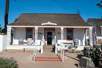
Many of the old buildings have been restored, including La Casa de Estudillo, which was built in 1827. Actually, the casa was restored in 1910 by the Spreckles family many years prior to it becoming a state historic park. The builder of the original adobe home was Captain Jose Marie de Estudillo, who commanded the San Diego Presidio.
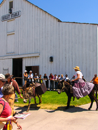
For an overview of early San Diego history, a slide program, given several times each day in the restored Seeley Stable, is a good beginning point for a visit to Old Town. The original stable belonged to Albert Seeley, who operated a very profitable stage line between San Diego and Los Angeles. However, as is so often the case, progress ended his business when Southern Pacific extended its railroad from Anaheim to San Diego in 1887.
For those interested in journalism, the original home of the San Diego Union newspaper has been restored to 1868 when its first edition came off press. So many other restored buildings have been transformed into museums, shops and restaurants.
The Plaza is the center of Old Town. As occurred during the Mexican period, the Plaza today is the scene of many ceremonies and fiestas. This is where the first U.S. flag was raised over San Diego in 1846. If there is no celebration in progress, the trees and benches provide welcome relief for feet tired from wandering about Old Town.
What most of the 4-million visitors each year come to Old Town San Diego for is the food. Old Town San Diego has a great choice of restaurants serving a wide selection of foods, although most tend to specialize in the tasty, spicy foods of old Mexico. Although it’s nearly impossible to go wrong, the food served in Old Town’s historic Cosmopolitan Hotel and Restaurant (also a B&B—619-297-1874) is great, especially if you can find a table in the old courtyard.
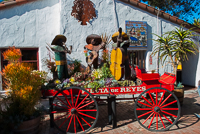
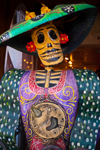
Fiesta de Reyes, another popular part of Old Town, creates a colorful, festive atmosphere with an abundance of beautiful flowers, set throughout its lawn and shops. The colors and textures of the art and gift items imported from many countries south of the border, and the wonderful aroma of delicious foods, blend into a montage that is pure sensual heaven. The experience will bring you back to Old Town each time you visit San Diego.
Old San Diego State Historic Park is located at San Diego Avenue and Twiggs Street. For more information you can call the park at 619-237-6766.
Copyright 2015 by Publishing Syndicate, all rights reserved.
For permission to reprint text or photos contact Ken@PublishingSyndicate.com
w186
Cuyamaca Rancho
State Park
About forty miles east and slightly north of San Diego lies a 25,000-acre park that has become a favorite mountain escape for many coastal city dwellers. Within the boundaries of Cuyamaca Rancho State Park there is a 13,000-acre wilderness area, a mountain peak reaching 6,512 feet that provides spectacular views of the ocean and desert, a lake, and the remnants of a gold mine that operated here until 1892.
Before the Spanish arrived during the late 18th century, the Kumeya’ay Indians lived here in Ah-ha-Kwe-ah-mac, the place where it rains. The Indians successfully fought Spanish encroachment into their mountains for more than 50 years, but finally were forced to sign a treaty in 1837, promising never again to attack Spanish settlements.
The Indians generally abided by the treaty, with one particular exception during 1847-48. When Cesario Walker attempted to build a lumber mill on Rancho Cuyamaca, by this time a Mexican land grant, he had to abandon the project because the Indians “made a kind of revolution.” A few years later, James Lassator homesteaded 160 acres in Green Valley. Unlike those settlers who preceded him, Lassator paid the Indians for the land and thus he and his family lived in peace in their stone house.
Following Lassator’s arrival, things changed rapidly in Cuyamaca. During the 1860s, gold was first discovered near today’s town of Julian. and then in 1870, a rich deposit was discovered within today’s park boundaries. Once word spread about Cuyamaca’s gold-bearing quartz ledges, hundreds of miners poured into the area, forcing out the few surviving Indians.
Stonewall Mine quickly became the largest and most profitable gold mining operation in the area. During its peak production years from 1887-91, over 200 miners worked here, and most lived in the adjacent town of Cuyamaca which had grown up around the mining operation. The mine, whose owner was Robert Waterman, the governor of California during 1887 to 1891, produced over $2 million dollars in gold. That was when gold prices stood at between $16 and $20 an ounce. At today’s gold price, that is equal to more than $40 million.
Following Waterman’s death in 1891, the mine closed and it, along with the surrounding property, was subsequently sold by a series of different owners. The last private holder of Cuyamaca was Ralph Dyar, who purchased the property in 1923. In 1933, Dyar sold it to the state for half of its appraised value. Harvey Moore, who had worked for many years as the ranch foreman, became the new state park’s first ranger and later its superintendent, a position he held until retiring in 1955.
From San Diego the quickest access to Cuyamaca is from the south via Interstate 8 to Highway 79. Upon entering the park, a sign directs drivers to tune their car radios to the park’s radio frequency where a recorded message repeats information concerning the park. The first developed area of the campground is the Green Valley picnic and camping area which sits near the Sweetwater River. While the river is actually only a small stream, it offers a rich riparian habitat that attracts much wildlife. There is a lovely, and very popular campground here that is situated in the wooded hills just above the river.
State Highway 79 bisects the entire length of Cuyamaca Rancho State Park, passing near all the park’s campgrounds and picnic areas. A good starting point if this is a first trip, is to the area headquarters which also houses a museum and interpretive center. There are a variety of publications for sale, from park brochures to plant identification guides.
The park is a great place for either camping, or for just spending a day picnicking or hiking. There are over a hundred miles of trails through terrain that varies from large open meadows to forested mountains. One particularly popular trek is the 3.5 mile trail that leads to the top of Cuyamaca Peak. Actually, the trail is an old fire road that climbs over 1600 feet from the trailhead near Paso Picacho Campground. A clear days, vistas stretch from Anza-Borrego Desert and the Salton Sea to the east, south to Mexico and west to the Pacific Ocean
Mountain bikers are also discovering Cuyamaca Rancho. About 50 miles of fireroads inside the park are open to mountain bikes. The roads are posted, and the park map (available at headquarters) designates the open areas.
Cuyamaca is extremely popular with horseback riding enthusiasts. About 50 miles of equestrian trails touch most areas of the park and special horse camp areas have been established near Cuyamaca Lake. The Los Caballos Horse Camp is a family camping area with 16 developed campsites, metal corrals, piped water and restrooms with hot showers. A nearby group equestrian camping area will accommodate 80 people and 45 horses in corrals. In addition, three primitive trail camps are available at Arroyo Seco and Granite Springs. Pit toilets and drinking water are available. Call the park for more information about the horse camping facilities.
For non-horse people, there are 81 campsites at Green Valley and 85 sites at Paso Picacho, near the northern end of the park. Green Valley is popular most of the year. Even during fall, weekend reservations are advised; during summer reservations are generally required to be assured a campsite at any of the campgrounds.
Winter visitors to Cuyamaca are often surprised by the relatively heavy snowfalls that can create considerable traffic problems along Highway 79. It is best to carry chains (and be sure they fit your car tires properly) if visiting during the winter months.
Summer visitors should carry water when hiking. Daytime temperatures can become quite warm and water is not available along most trails.
Although Cuyamaca Lake itself is not part of the state park, a park trail follows along its southern shore to some very popular fishing spots. There is also boat access at a private marina area just outside the park, off Highway 79.
For camping reservations, call 1-800-444-7275. You may reach the park during business hours at 619-765-0755.
Copyright 2015 by Publishing Syndicate, all rights reserved.
For permission to reprint text or photos contact Ken@PublishingSyndicate.com
w187
Leo Carillo State Beach
&
Point Mugu
State Park
What do Leo Carrillo State Beach and nearby Point Mugu State Park have in common? Besides their popularity with visitors as pristine Southern California beach destinations, they both have networks of foot, horse and mountain bike trails.
Many parks and beaches within the California State Park System are adjacent to federal lands, and such is the case here. Over half of Leo Carrillo’s 2,000 acres connect with the Santa Monica Mountains National Recreation Area, as does the much larger 15,000-acre Point Mugu found to the north; the sharing of these jurisdictions is of benefit to all, granting visitors access to more of this wondrous part of California.
Leo Carrillo State Beach
This beach, like several of Southern California’s beaches and parks, has taken the name of a film celebrity. Although most people today may not recognize the name, as an actor, the late Leo Carrillo had a very successful film, Broadway, and television career. Perhaps his best known part was that of Pancho, the Cisco Kid’s sidekick in the popular 1950s’ television series. Leo Carrillo, the great grandson of one of California’s last governors during Mexico’s rule and a past member of the California State Parks Commission, was very instrumental in the acquisition of several key state parks, including the one carrying his name.
Along the park’s one mile stretch of beach, there is plenty of room for the kids to run, adults to beachcomb and all to swim. Arroyo Sequit, a small, seasonal creek that runs through the middle of the park, forms a low, rocky, inter-tidal area where it empties into the ocean not far from the park’s entrance. It’s a great place to explore during low tides. Sea slugs, tube worms, turban snails, mussels, and sea urchins live on and among the rocks.
While most tide pools animals are protected, ocean fishing is allowed and quite popular at Leo Carrillo. Anyone with the equipment and a little luck can catch kelp bass, surf or shiner perch and an occasional halibut. A little more exciting are the thresher sharks, shovelnose guitar fish, and California corbina that anglers also pull from the surf.
Scuba divers also like the beach at Leo Carrillo. Easy access to nearby kelp beds, the clear water, and the bounty of underwater plant and animal life offers great opportunities for exploration. Just remember not to dive alone.
The park has three campgrounds, one of which is for groups only. The others handle tents, with some sites accommodating trailers and motorhomes (no available hook-ups). The campground on the ocean side of Highway 1 does not allow RVs because the access tunnel that goes beneath Highway 1 can only accommodate vehicles under 8 feet in height.
Leo Carrillo is about 26 miles north of Santa Monica, at the intersection of Mulholland Highway and the Pacific Coast Highway (Highway 1). For general park information, call (310) 457-8143 or (818) 880-0350. Camping reservations can be made through “Reserve America” at (800) 445-7275 or on-line at www.reserveamerica.com.
Point Mugu State Park
The Chumash Indians called this area Muwu, or “beach.” Today, Point Mugu State Park remains a popular ocean beach, with the vast majority of the park extending about seven miles inland, including the 6,000-acre Boney Mountain State Wilderness. Within the park’s total 15,000 acres its highest point rises 3,010 feet above sea level.
Most of the visitation is focused along the beach and in Big Sycamore Canyon that runs northwest through the length of the park. The canyon is home to the largest groves of sycamores protected within California State Parks. Both sycamores and coast live oaks dominate the lower canyons, while chaparral covers the sides of the upper mountains. Blue elderberry, wild rose, California bay, and the ubiquitous poison oak, are very common. The park’s La Jolla Valley Loop trail travels through a native tallgrass prairie, something rarely seen in California anymore.
With such a diversity of habits, from grasslands and oak woodlands, to chaparral and the bedrock outcroppings of the Boney Mountains, wildlife within the park is equally diverse. Southern mule deer, gray foxes, striped and spotted skunks, badgers, bobcats, and mountain lions, live here, just a few miles from several million people. Along the coast, sea lions and harbor seals can be seen playing along the surf line, while gray whales and large schools of dolphins often pass near shore during their migrations. Located 15 miles south of Oxnard off of Highway 1, Point Mugu State Park offers camping and picnic facilities. For general park information call (310) 457-8143. Camping reservations can be made through “Reserve America” at (800) 445-7275 or on-line at www.reserveamerica.com.
Copyright 2015 by Publishing Syndicate, all rights reserved.
For permission to reprint text or photos contact Ken@PublishingSyndicate.com
w189
Woodson Bridge
State Recreation Area
Near Northern California’s olive capital of Corning, concealed among valley oaks, sycamores, willows, ash, and black walnut trees, lies Woodson Bridge State Recreation Area. This little treasure of a park is bypassed by most people speeding down Interstate 5, but for a quiet afternoon picnic, a weekend campout or a day fishing, it’s hard to beat.
Compared with most state parks, Woodson Bridge is relatively small, just 142 acres, but much of it is situated along the Sacramento River. The size of the main park is deceiving. There is also a 328-acre preserve adjacent to the state recreation area that is a lush riparian forest and a county park with picnicking and boat launching facilities.
Within the park’s preserve you can see bald eagles and rare yellow-billed cuckoos. While bald eagles search the river banks and shallows for fish, the cuckoos prefer the heavily wooded forest areas where they feed on a variety of insects. Adult bald eagles, with their large size and prominent white head and tail, are easy to spot. The cuckoos are more of a challenge for birders. Only about a foot long, they have large white spots at the ends of their black tail feathers. And there may be some disappointment to learn that unlike their European cousins that sing their popular coo-coo song, the park’s yellow-billed cuckoos let out a long series of notes that sound more like kakakaka ka ka ak ka-oh ka-oh kow kow.
What draws most people to Woodson Bridge isn’t the birds, but the fishing. There’s large migratory fish swimming up the Sacramento River past the park nearly every month of the year. The salmon run is best during the fall and winter seasons, but still are moving upriver into spring. The October and November salmon runs are joined by steelhead, adding more challenge and fun for anglers. Summer’s heat brings with it shad fishing. Casting shad flies into a school of shad during June and July can add a new dimension of excitement for both novice and old fishing hands. There’s striped bass running upstream during summer, and catfish to be found year-round in some of the park’s backwater areas such as Koptka Slough. Call the park for the best fishing locations or check locally for the most up-to-date fishing information.
Summer also marks the beginning of a different kind of migration—people begin heading to the river’s refreshing waters. The park’s sand and gravel beaches provide a great place to relax and cool-off without driving to the higher mountains. But remember, the river always harbors unseen dangers. Moving currents, unexpected drop-offs and cold water can be deadly, so always use caution and life jackets for all kids and adult non-swimmers.
Visitors are greeted with a profusion of colors during spring as numerous species of wildflowers blossom among the trees and in the park’s more open meadow areas. Fall is a great time to bring cameras and painting easels, as the shorter, cooler days of autumn transform the many shades of green leaves into bright yellows and reds as the deciduous oaks, cottonwoods, black walnuts, sycamores and willows drop their leaves to the forest floor.
Woodson Bridge SRA is located six mile east of Interstate 5 at Corning, or three miles west of Highway 99 at Vina. The campground’s 41 sites are available on a first-come, first-served basis from October through April and subject to reservation May through September via Reserve America. For more information contact the park at 530-839-2112.
Copyright 2015 by Publishing Syndicate, all rights reserved.
For permission to reprint text or photos contact Ken@PublishingSyndicate.com
w190
Elkhorn Slough
California’s coastal estuaries and marshes are some of the most prolific producers and supporters of wildlife in the world. The 3,000 acres of marsh and tidal flats and the 7 miles of main water channel that comprise much of Elkhorn Slough National Estuarine Research Reserve and the adjacent Moss Landing Wildlife Area are home, either permanently or as a seasonal sanctuary, to more than 400 species of invertebrates and 80 species of fish. There are 267 species of birds on the estuary’s bird list. Yet, the unfortunate fact is that during the past century, nearly 90 percent of these same rich wetlands in California have been filled, drained, or in other ways destroyed. Even Elkhorn Slough has seen extensive commercial operations, such as the 200 acres of commercial salt ponds that were in production from the early 1900s until 1974. Today the ponds have been reclaimed and serve a much more valuable role as rich feeding grounds for dozens of bird species and a summer resting ground for the endangered brown pelican.
The salt flats aren’t the only areas of the slough that have been restored. Much of the marshland was diked and drained during the earlier part of the century and used as grazing land for the Elkhorn Dairy operation. Two of the old barns remain on the property, and are now home to bats, barn owls, and other wildlife. Most of the dikes are gone, at least those that were able to restrict the ebb and flow of seawater and fresh water. The land that has been reflooded today serves as a valuable research area where the success of such wetland restorations can be studied and new and better techniques developed.
Several trails wind through the estuary, most starting near the visitor center. And the visitor center is a great first stop. The exhibits are both enlightening and entertaining. The gigantic foot of a great blue heron, stepping down through the center’s ceiling onto an equally oversized model of an underwater mud flat, its beak grasping a fish, is quite fascinating. The model also provides a great look at the creatures that thrive in the water and under the mud flats of the estuary. For wildflower enthusiasts, another exhibit displays a sampling of the flowers and plants that are most likely to be seen near the trails. The plants and wildflowers found here during any season are as varied and rich as the bird life. Sticky monkey flower (Mimulus aurantiacus) and wild buckwheat (Eriogonum nudum) are found in the drier areas, along with fennel (Foeniculum vulgare) and Socrates’ last drink, poison hemlock (Conium maculatum). Closer to the edges of the marsh are mugwort (Artemisia douglasiana), pickleweed (Salicornia virginica), and salt marsh dodder (Cuscuta salina var. major). About 90 percent of the vegetation covering the salt marsh is pickleweed, one of several plants that have adapted to the high concentrations of salt water. Leaves, which store the excess salt absorbed during the growing season, are dropped during winter. Along the upper trails, dark green swathes of oak woodland, with their coast live oak (Quercus agrifolia), contrast with patches of open grasslands. And to reinforce the need to remain on the trails some areas are bordered by thick hedges of poison oak (Toxicodendron diversilobum).
The visitor center also provides free bird lists that include the seasons when the different birds are most likely to be seen. Summer brings large numbers of brown pelicans (Pelecanus occidentalis) to the mud flats, along with numerous species of shorebirds searching the wet mud for food. The prominent white, great egrets (Casmerodius albus) are here year-round, as are the great blue herons (Ardea herodias). As an important winter stopover along the Pacific Flyway, Elkhorn Slough provides refuge for Canada geese (Branta canadensis), green-winged teal (Anas crecca), pintails (Anas acuta), gadwalls (Anas strepera), American widgeon (Anas americana), common goldeneyes (Bucephala clangula), and ruddy ducks (Oxyura jamaicensis). Jaegers (Stercorarius pomarinus), gulls (Larus sp.), terns (Sterna sp.), and a plethora of more terrestrial birds are commonly seen by bird watchers.
Directions: From Highway 1 at Moss Landing, turn onto Dolan Road and drive approximately 4.6 miles to Elkhorn Road. Turn left and drive another 2 miles to the visitor center entrance on the left.
Activities: Hiking, bird-watching.
Facilities: Visitor center with a small gift shop, trails.
Dates: Open Wednesday through Sunday.
Fees: None for anyone with a valid California hunting or fishing license, otherwise a small fee for those age 16 and over.
Closest town: Moss Landing, 6.5 miles.
For more information: Elkhorn Slough Office, 1700 Elkhorn Road, Watsonville, CA 95076. Phone (831) 728-2822.
Copyright 2015 by Publishing Syndicate, all rights reserved.
For permission to reprint text or photos contact Ken@PublishingSyndicate.com
Publishing Syndicate
PO Box 607 Orangevale CA 95662
Ken@PublishingSyndicate.com
Copyright 2010-2016 by Publishing Syndicate: All rights reserved