
w191
Andrew Molera
State Park
The Esselen Indians were the first to live in this area of Big Sur, although their home was first invaded by the Spanish, then taken over by the Mexicans, who were then soon overwhelmed by the Americans. The pioneers who settled the Big Sur area during the Mexican and the early American eras were a hardy and independent bunch. Andrew Molera State Park originally was part of a nearly 9,000 acre Mexican land grant known as Rancho El Sur, much of which remains intact today.
Captain John Rogers Cooper, born in England but living in America, sailed around the Horn, landing in California where his skills as a seafaring captain provided the money to purchase property. In 1840, he traded his Salinas Valley property for Rancho El Sur, which passed to his children following his death. Over the years the property transferred down the line of heirs, finally ending in the hands of Frances Molera. The Coopers, and later through marriage, the Moleras, operated their land as a cattle and dairy ranch. Andrew Molera became well known locally for the wagonloads of Monterey Jack cheese he regularly hauled to Monterey. In 1968, Frances Molera sold what was to become Andrew Molera State Park to The Nature Conservancy with the provision that it not be developed. The park was named for her gracious and well-liked brother, Andrew.
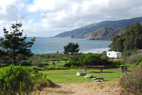
Today, Andrew Molera State Park provides public access to hills and meadows and to the Big Sur River where it meanders through Creamery Meadow and empties into the Pacific Ocean. The park offers a number of recreation opportunities, including rental horses during summer and a hike-in campground, access to over 2 miles of beach, and many miles of trails that allow exploration of coastal chaparral, oaks, and redwoods. There are exceptional views from the park’s bluff and ridge trails.
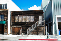
The old Molera ranch house, located a short walk from the park’s entrance kiosk, has been restored and turned into a visitor center and museum. The volunteers who operate the facility can answer questions about trails and the park’s history. Some of the ranch house rooms contain exhibits from the Ventana Wilderness Society, which works nearby in the park doing avian research and rehabilitation and release of California condors.
The campground is unique in state parks. There are no specific campsites; simply find a spot in the large meadow that is designated for camping. It’s all first-come first-served and it’s a short walk of about 0.25 mile from the parking lot to the campground. It’s not unusual to see people hauling camping equipment in backpacks or in little red wagons. It’s also very important to remember that some of the wiliest raccoons around thrive in the campground, sometimes shredding tents and opening ice chests to get to food. Keep all food well secured and remember that food inside a tent or in a backpack is not secure.
As soon as the trails dry from winter’s rain, the horseback riding concessionaire in the park opens for business. It provides an opportunity to ride many of the trails, including out to the beach. It’s a great way to introduce the younger set to trail riding.
Directions: The park is about 20 miles south of Carmel on Highway 1, and about 2 miles south of Point Sur State Historic Park.
Activities: Hiking, bird-watching, fishing, beachcombing, horseback riding, camping, bicycling.
Facilities: Visitor center and horse rentals during summer, campground.
Dates: Park is open daily. The visitor center open hours and days vary.
Fees: There are small fees for day-use vehicle entry and for the hike-in campground. The visitor center is included in the day-use fee.
Closest town: Carmel, about 20 miles north is the closest to offer full services. Limited public services are available about 6 miles south in the community of Big Sur.
For more information: Big Sur Station, 0.25 mile south of the Pfeiffer Big Sur State Park entrance. Phone (831) 667-2315.
TRAILS
The Big Sur River Trail is easily the most traveled because it leads from the parking lot on the northwest side of the river, through the hike-in campground, and ends at the mouth of the Big Sur River. The trail passes the old Cooper cabin, which is nestled in a grove of eucalyptus trees. The trees, in turn, attract thousands of monarch butterflies during winter. Hike up a short spur trail from near the mouth of the Big Sur River to the promontory at the head of Molera Point, which is a great place to sit and contemplate life or watch for whales. During summer there’s usually a seasonal bridge in place near the mouth of the river, but if not, most people simply wade across, although the water can be nearly waist deep. It’s best to ask at the entrance gate about the river’s level, or simply watch where some of those who visit the park on a more regular basis safely cross.
Also leaving from the parking lot, the Creamery Meadow Trail parallels the river on the southeast side, loops through the meadow, and after about 0.75 mile meets several other trailheads as it nears the beach. It’s quite level and many people like to ride bicycles. The only problem with this trail is that the seasonal bridge that crosses the Big Sur River at the parking lot is removed in the fall and isn’t reinstalled until late spring or early summer, when the river’s water level drops.
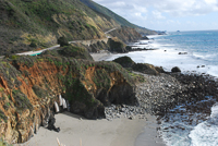
While the Molera Beach Trail is not an actual trail, the beach stretches to the south of the Big Sur River mouth more than 2 miles. While there are a couple of rocky outcroppings that block passage at high tides, during very low tides there is access to some very lonely and very beautiful stretches of beach. Just don’t forget to pay attention to the tide tables or getting back will be impossible, at least until the next low tide. The bluff above the beach is difficult, if not impossible to scale in most places.
Copyright 2015 by Publishing Syndicate, all rights reserved.
For permission to reprint text or photos contact Ken@PublishingSyndicate.com
w192
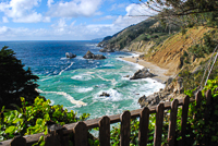
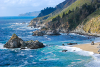
Big Sur Coast
Highway 1, where it meanders along the Big Sur coast, is designated as both a National Scenic Highway and an All-American Highway. Heading south from Carmel, it is about 26 miles to Big Sur, yet when visitors ask the Big Sur locals just exactly where Big Sur is, they are generally answered with a shrug. Big Sur is thought of more as a state of mind than a specific place. It’s the sheer rugged terrain and the fog-shrouded cliffs that tower above the highway. It’s the waves that crash into the rocky shore and the wildflowers that cast their colorful hues on the mosaic of mountainside vegetation. It’s the remoteness, the quiet, the night skies, bright with stars, and the daytime skies even more blue than the Pacific’s vast waters. It is a state of mind. But, the Big Sur coast does not end at the community of Big Sur. It continues south, unofficially ending somewhere near San Simeon.
Copyright 2015 by Publishing Syndicate, all rights reserved.
For permission to reprint text or photos contact Ken@PublishingSyndicate.com
w193
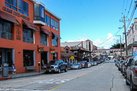
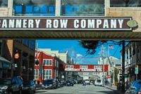
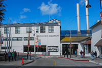
Monterey's Cannery Row
The stench of sardines that permeated the heart and soul of this corner of Monterey and extended into neighboring Pacific Grove 50 years ago has long since disappeared, although a quick read of John Steinbeck’s Cannery Row can quickly bring it back to life, at least in one’s imagination. Also gone are the canneries that first began appearing here in 1902. Those first canneries processed salmon and abalone for the San Francisco market. As that market faded, the sardine fishery slowly began to take its place. Within a few years, improved technology and work practices allowed fishing boats to unload their holds more efficiently and quickly, and factories to significantly increase the speed and efficiency of their canning processes.
As World War II raged, sardines became the mainstay of the Monterey fishing industry. Following a night of fishing, the boats, most large purse seiners, would return to unload as much as 70 tons of sardines into the factories, which processed most of the fish into fishmeal and fertilizer. On the first night of the sardine fishing season in 1949, some 52 purse seiners and 16 smaller boats returned to Monterey’s canneries with over 2,500 tons of sardines.
By the early 1950s, the sardine industry was in serious trouble. An entire season would see no more than what had been a slow night’s catch in 1940. Overfishing, water temperature changes, pollution, and any number of other contributing factors brought the sardine industry to its knees and sent its owners into bankruptcy. The years that followed were not any kinder to the Cannery Row waterfront. The abandoned canneries fell into disrepair, and the entire area became a blight on the edge of Monterey Bay. Urban redevelopment and an increasing tourist industry finally started bringing the Row back to life. Some of the remaining canneries were transformed into shops, restaurants, and amusement centers. The opening of Monterey Bay Aquarium in 1984 brought a huge increase in tourism to the area. It also spurred further enhancements to the surrounding areas.
Just wandering around Cannery Row’s several blocks can be an adventure in itself. Many of the old structures are a maze of corridors and walkways, stairs, and passages that lead from one unique shop to another and from myriad restaurants to wine tasting rooms. There are carousels and jewelry stores, kayak rentals and bicycle rentals.
At the east end of Cannery Row, adjacent to the U.S. Coast Guard pier entrance, scuba divers have discovered San Carlos Beach. Actually the city of Monterey developed the park, including plenty of parking (metered), and added a restroom and outside showers specifically to accommodate the large number of scuba divers who come here. It’s a very popular place for beginning divers. The large grassy area offers plenty of space for picnics and for just relaxing after a day of diving.
Directions: From Del Monte Avenue near Fisherman’s Wharf, stay in the right lanes and continue west through the tunnel. Take the first right turn, which is Foam Street. Drive to the first traffic light and turn right, go the two blocks to the bottom of the hill. The road swings left and becomes Cannery Row. San Carlos Park is on the right.
Activities: Walking, dining, scuba diving, shopping.
For more information: Monterey Peninsula Visitor and Convention Bureau inside the Stanton Center/Maritime Museum of Monterey on Custom House Plaza. Phone (831) 649-1770.
Copyright 2015 by Publishing Syndicate, all rights reserved.
For permission to reprint text or photos contact Ken@PublishingSyndicate.com
w194
Carmel River
State Beach
Carmel River State Beach, with its lagoon and wetland, is located about 1 mile south of Carmel on Highway 1. There’s a small beach with pull-out parking along the highway, and it’s only a short walk to the water. Carmel River State Beach, or at least the small section closest to Highway 1, is better known locally as Monastery Beach. Scuba divers frequently use this beach. It’s also a dangerous beach, with sleeper waves, cold water, and a fairly steep drop-off. Stay back, and don’t allow children to play close to the water.
There are two additional accesses to the long stretch of beach area that is much larger than it appears when speeding down Highway 1. There is access to a wonderful wetlands area and much more beach if you hike for about 15 minutes along the beach from the highway. An alternative access to the wetland area is located off Highway 1, just south of the Carmel River bridge. Turn onto Ribera Road into a small, hilltop residential neighborhood. There is a trail to the wetland area and to the beach where the street dead-ends into a cul-de-sac. There’s also a hill promontory that provides a nice view of the area. Be sure not to block anyone’s driveway when parking.
A third alternative is to drive into the town of Carmel and meander around the twisting streets down to Scenic Avenue, which parallels the coast and passes homes that rival many of those in Pebble Beach. There’s a parking lot off Scenic Avenue at the mouth of the Carmel River. Depending upon whether or not the river is flowing all the way to the ocean or is blocked by the seasonally forming sand dam, you can explore many more miles of beach.
Directions: Carmel River State Beach is located adjacent to Highway 1, about 1 mile south of Carmel.
Activities: Beach exploring, scuba diving, hiking, bird-watching.
Dates: Open daily.
Fees: None.
Closest town: Carmel, about 1 mile north.
For more information: Point Lobos State Reserve, about 2 miles south of
Carmel, phone (831) 624-4909.
Copyright 2015 by Publishing Syndicate, all rights reserved.
For permission to reprint text or photos contact Ken@PublishingSyndicate.com
w195
Estero Bay
Estero Bay is one of those indentations in the California coast that offers little or no protection from ocean storms, but still it is called a bay. There are three small communities along the Estero Bay: Cayucos, Morro Bay, and Los Osos. Cayucos lies at the northern end of the bay, adjacent to Highway 1. Turn off Highway 1, which actually runs east and west here, and head south to the Cayucos Pier, for what is generally very good ocean fishing. Like anywhere, the fish bite when they’re ready to bite, but here, there’s a better-than-even chance of hooking something besides kelp. It also helps to check one of the nearby bait shops or ask another fisherman on the pier about what’s being caught and what everyone is using for bait.
In close, near the breaking surf, anglers regularly catch barred surfperch (Amphistichus argenteus). Out a bit farther, brocaccio (Sebastes pancispinis) and walleye surfperch (Hyperprosopon argenteum) are commonly landed, and the deeper water at the end of the pier produces catches of small (8-inch) shiner perch (Cymatogaster aggregata), which are then used as bait for much larger and tastier Pacific halibut (Hippoglossus stenolepis).
Morro Stand State Beach (phone 805-772-7434) is not far off the Highway 1, and is also in the town of Cayucos. There’s a 3-mile stretch of sandy beach that is popular for fishing, beachcombing, and picnicking.
Directions: From Morro Bay, drive 6 miles north on Highway 1 to Cayucos and take either Ocean Boulevard or Cayucos Drive and continue south to the pier.
Activities: Fishing, beachcombing.
Facilities: The surrounding town of Cayucos offers complete services.
Dates: Open daily.
Fees: None for use of the pier.
For more information: Cayucos Chamber of Commerce, 241 South Ocean Avenue, Cayucos, CA, 93430. Phone (800) 563-1878 or (805) 995-1200.
Copyright 2015 by Publishing Syndicate, all rights reserved.
For permission to reprint text or photos contact Ken@PublishingSyndicate.com
w196
Garrapata State Park
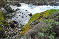
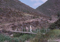
The park possesses absolutely nothing in the way of human creature comforts, but it does offer several public access points to miles of rugged Big Sur coast and several more miles of trails that climb the steep mountains that immediately rise to the east. In Spanish, garrapata means “tick.” And ticks abound in the area, especially during spring and early summer. But in spring, the sight of entire mountainsides carpeted with the rich yellows and reds and purples of wildflowers is worth taking a few simple precautions, such as applying repellent, to protect yourself from ticks. There’s a fence that parallels much of the park along the west side of Highway 1, with several numbered gates located at the trailheads that lead to trails or stairways that offer relatively safe access from the ocean terrace down the steep cliff face to the beaches. Generally, just look for other cars parked along the highway to find the most popular access points.
The ocean here can be extremely hazardous, especially during summer. Sleeper waves are relatively common, sweeping people off beaches and rocks every year. Never turn your back on the ocean.
Directions: Take Highway 1, about 4 miles south of Carmel.
Activities: Hiking, fishing, beach exploring.
Facilities: There are a couple of chemical toilets.
Dates: Open daily.
Fees: None.
For more information: Point Lobos State Reserve, 2 miles south of Carmel, phone (831) 624-4909; or Monterey District State Parks, 2211 Garden Road, Monterey, CA 93940. Phone (831) 649-2836.
Copyright 2015 by Publishing Syndicate, all rights reserved.
For permission to reprint text or photos contact Ken@PublishingSyndicate.com
w197
Guadalupe-Nipomo
Dunes Preserve
There’s an 18-mile stretch of coastal dunes that is a fascinating home to both fact and fiction. The facts include that the middens filled with shells indicate that Chumash Indians used the dunes for perhaps 8,000 years prior to the arrival of Juan Cabrillo in 1542 and Gaspar de Portolá’s expedition in 1769. It’s also a fact that famed director Cecil B. DeMille created a huge set here for his 1923 silent film, The Ten Commandments. It’s fiction that the set still exists buried beneath the sand, although some remnants of the bulldozed structure remain visible.
It’s also true that during World War II this portion of California’s coast, like many others, was in need of constant observation to be sure that a Japanese invasion was not imminent. But not all was as it appeared. The bunkers sported long poles designed to imitate the cannons that didn’t exist.
This stretch of sand has the highest beach dunes in the western United States. Wind began forming the dunes here 18,000 years ago, resulting in huge accumulations of sand such as found at Mussel Rock Dune, which rises 500 feet above the nearby ocean. The oldest dunes are actually farther inland, atop the Nipomo and Orcutt mesas east of the preserve. They have been stabilized by vegetation, leaving only the newer beach dunes created since the end of the Pleistocene Epoch to blow and move with the ocean winds.
Few plants can survive the sharp, cutting edges of blowing grains of sand and the overall hostile growing environment that sand provides. With the reduced number of dunes along California’s coast, many of these plants have also become rare or endangered. La Graciosa thistle (Cirsium longcholepis), beach spectacle pod (Dithyrea maritima), crisp dune mint (Mondardella crispa), and surf thistle (Cirsium rhothophilum) have managed to develop the ability to slow the blowing sand enough to create stable deposits that in turn allow other plants to become established. Within the bare dunes and the more stable coastal dune scrub more than 200 species of birds live, either as residents or migrants. Brown pelicans (Pelecanus occidentalis), least terns (Sterna antillarum), and snowy plovers (Charadrius alexandrinus) are relatively easy to see, even considering their status as threatened species.
Directions: There are two entrances to Guadalupe-Nipomo Dunes Preserve. From Highway 1 drive to Oso Flaco Road about 4 miles north of the town of Guadalupe. Turn west and follow the Oso Flaco Road to the park entrance and the parking area. It’s a short walk to the lake and to the dunes just beyond. The second entrance allows visitors to drive through the dunes and park at the beach. From Highway 1 turn west onto West Main Street (Highway 166) just south of the town of Guadalupe and drive about 3 miles down a road that passes through farm fields to the entrance. It’s another 2 miles to the beach parking lot.
Activities: Hiking, fishing, beachcombing.
Facilities: None.
Dates: Open daily.
Fees: The first access (Oso Flaco Lake) is through state park property, so there is a small day-use fee. The second entrance is through The Nature Conservancy gate. A small donation is requested to enter.
Closest town: Guadalupe, 5 miles or Arroyo Grande, about 18 miles.
For more information: The Nature Conservancy, Public Use Manager, Guadalupe-Nipomo Dunes Preserve, PO Box 1004, San Luis Obispo, CA 93406. Phone (805) 544-1767.
Copyright 2015 by Publishing Syndicate, all rights reserved.
For permission to reprint text or photos contact Ken@PublishingSyndicate.com

w198
Julia Pfeiffer Burns
State Park
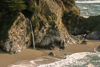
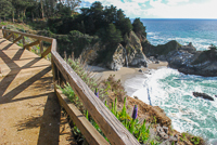
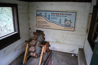
The steep canyon walls that rise from the parking lot make this appear to be a small park, yet it covers 3,600 acres, with 1,680 of its acres offshore and underwater. Most visitors seldom get beyond the short trail that leads to an overlook above McWay Falls, which drops 80 feet, at one time directly into the ocean, but now onto an inaccessible stretch of beach. There’s a small stand of redwoods up he McWay Creek, beginning at the parking lot. The few picnic tables in the area get substantial use. A short distance up a dirt road at the end of the parking lot turn-around, the McWay barn is slowly deteriorating, although work has begun on restoring it. Spring and early summer are the best times to visit. The creek is running full and the hillsides are covered with wildflowers.
The park’s underwater reserve is open to very experienced divers only. Diving permits are required. The inland portion of the park extends from the rocky shore to nearly 3,000 feet in elevation in the mountains immediately to the east. McWay Creek canyon supports small groves of coast redwoods. Scattered among the redwoods, tanoak (Lithocarpus densiflorus), madrone (Arbutus menziesii), and California laurel (Umbellularia californica) are the dominant trees, with redwood sorrel (Oxalis oregana), trillium (Trillium ovatum), and columbine (Aquilegia formosa) thriving beneath their shading branches. Farther up the hillsides, the Central Coast’s common chaparral species dominate. Sticky monkey-flower (Mimulus aurantiacus) and morning glory (Ipomoea purpurea) are joined by shrubs such as the ubiquitous poison oak (Toxicodendron diversilobum).
Christopher McWay and his son Christopher Jr. originally settled this area of the Big Sur coast in 1874, when they began their ranching operation. Over the next two decades they filed land claims for what became known as Saddle Rock Ranch. Today many of the area’s landmarks still retain the McWay name.
In 1921, former New York State Congressman Lathrop Brown and his wife, Helen Hooper of Boston, following 10 years of active social, political, and business activity, began traveling extensively throughout the world. They fell in love with Big Sur, and within a few years had acquired much of the original McWay property. The house they built, although not extravagant by the standards set by William Randolph Hearst’s home farther south, had a much more spectacular view. Their “Waterfall House,” was perched on the cliff overlooking McWay Cove and the 80-foot-high waterfall that tumbled directly into the ocean. They also had electricity in their home long before powerlines stretched along the Big Sur coast, the power created by a small Pelton wheel generator set on nearby McWay Creek.
Their remote home allowed for few neighbors, but Mrs. Brown became especially good friends with Julia Pfeiffer Burns, the daughter of Michael Pfeiffer, head of Big Sur’s best known pioneer family. The Browns did enjoy entertaining, and following the completion of Highway 1, access to the retreat became much easier. While a list of their guests isn’t known, Lathrop Brown, in his college years, roomed with Franklin Delano Roosevelt at Harvard and was also best man at Roosevelt’s wedding. It’s likely the Brown’s guests included many well-known socialites of the day.
Mrs. Brown insisted that their house be demolished when she gave Saddle Back Ranch to the California State Park System in 1962. She also required that the new state park be named after a “true pioneer” and her good friend, Julia Pfeiffer Burns, who had died 35 years earlier. Today, all that remains of the Brown’s home is a stone terrace and some of the surviving exotic plants that the Brown’s had imported for their gardens. During January through March the terrace is a great place to watch migrating gray whales.
Directions: Drive south on Highway 1, about 12 miles south of Big Sur. The main entrance and parking lot are on the inland side of Highway 1.
Activities: Hiking, whale-watching, camping, and picnicking.
Facilities: There are picnic tables at the parking lot and two environmental campsites on the ocean bluff.
Dates: Open daily.
Fees: There are day-use and camping fees.
Closest town: Big Sur, about 12 miles north.
For more information: Contact the Big Sur Station, phone (831) 667-2315.
Trails
From the parking lot that is located just off the east side of Highway 1, the Waterfall Trail is a short walk through a tunnel that passes under Highway 1 and then continues along the bluff overlooking McWay Falls. While the waterfall that cascades over the cliff once splashed directly into swirling ocean waves, during the El Niño winter of 1983-84, a massive landslide from the steep cliffs above raised the beach several feet. The waterfall now crashes onto the beach very near the waves that wash across the shore. The trail continues on another 100 yards or so offering ever-changing views of the falls. The short trail ends at a promontory that was the site of the Brown’s house.
The Ewoldson Trail begins at the eastern end of the parking lot at McWay Canyon and meanders up the canyon and out across the mountainside. It’s about 4.5 miles roundtrip and offers spectacular views back into the mountains and of the ocean.
The Partington Cove Trail [Fig. 44(15)] is located near the north boundary of the Julia Pfeiffer Burns State Park, along Highway 1. On the Ocean side of the highway there’s a wide, dirt pull-off at Partington Cove, but unfortunately, no road sign to identify the cove. Often there are other cars parked here. There are two trails, one on each side of the highway. On the ocean side, it’s a quick 0.4 mile walk down to a small, rocky cove where Partington Creek runs into the ocean.
At the same Partington Cove parking area, but on the inland side of the highway, the Tan Bark Trail [Fig. 44(15)] picks up and meanders up the canyon and into the mountains for about 3 miles. There’s an optional route back, but unfortunately it returns to Highway 1 about 1.5 miles south of Partington Cove, so it’s a bit of a hike back to the parking area.
Copyright 2015 by Publishing Syndicate, all rights reserved.
For permission to reprint text or photos contact Ken@PublishingSyndicate.com
w199
Monterey Bay Kayaking
There’s nothing more relaxing than paddling silently, almost effortlessly, across the calm waters of Monterey Bay, watching the sea otters watch you. The kelp beds offer sanctuary to many animals, and sitting in a kayak is the best way to experience the edge of the bay. Mornings are the best time to go, before the afternoon winds have managed to kick up the waves a bit more than beginning kayakers might find comfortable. For renters, there are two basic types of kayaks available in the rental shops in Monterey. Many people choose the sit-on-top kayaks, which are great if it happens to be a warm day and you don’t mind getting a little wetter than you would paddling in a sit-inside kayak. But both are great fun. Lessons are available and a short session with a qualified instructor from any of the shops will make the day much safer and more enjoyable for beginners. For anyone with his or her own kayak, Monterey State Beach, across Del Monte Avenue from Lake El Estero, has a long, gentle, sandy beach that offers easy kayak launching. There’s free parking along Del Monte Avenue and it’s just a short carry across the grass to the beach.
Directions: Easiest launching is just off Del Monte Avenue, across from Lake El Estero at Monterey State Beach.
Fees: Parking along the street is free. There is a small, metered parking lot at the end of the grassy area, adjacent to the Monterey Bay Kayaks shop.
For more information: Several companies rent kayaks including Adventures by the Sea, 299 Cannery Row in Monterey, phone (831) 372-1807; Monterey Bay Kayaks, 693 Del Monte Avenue, Monterey, phone (831) 373-5357.
Copyright 2015 by Publishing Syndicate, all rights reserved.
For permission to reprint text or photos contact Ken@PublishingSyndicate.com
w200
Lighthouse Field
State Beach
& Surfing Museum
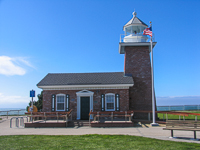
Along West Cliff Drive where joggers run and in-line skaters cruise not far from the edge of the bluff, Lighthouse Field State Beach is one of those places that most visitors to Santa Cruz unfortunately miss, especially if their focus is the wilder times to be had at the beach and boardwalk. Here, Point Santa Cruz juts out to mark Monterey Bay’s northern boundary.
The original lighthouse was built here in 1869, as an aid to navigation for the constantly increasing numbers of ships that passed by, heading to and from San Francisco. Within 10 years of its construction, the crashing waves had eroded so much of the cliff face that the structure was moved farther inland where it continued in operation until 1941. The lighthouse structure was replaced by an automatic beacon-topped wooden tower and the original wooden lighthouse was sold for scrap.
Today’s stone lighthouse that stands near the cliffs was a gift to the people of Santa Cruz. Photographers Chuck and Esther Abbot sponsored the construction of the new lighthouse in memory of their son Mark, who was killed in a surfing accident. Today, the lighthouse houses a small museum dedicated to Santa Cruz’s long history of surfing.
Directions: In Santa Cruz, from where Ocean Avenue, Beach Street, and West Cliff Drive intersect near the foot of the wharf, follow West Cliff Drive north along the bluff several blocks to the lighthouse.
Activities: Surfing, fishing, bicycle riding, jogging, bird-watching.
Dates: Lighthouse Point is open daily; the lighthouse surfing museum is open Wednesday through Monday (closed on Tuesdays).
Fees: None.
For more information: Santa Cruz Surfing Museum, West Cliff Drive, Santa Cruz, CA 95062. Phone the museum (831) 420-6289 or the park (831) 429-3429.
Copyright 2015 by Publishing Syndicate, all rights reserved.
For permission to reprint text or photos contact Ken@PublishingSyndicate.com
Publishing Syndicate
PO Box 607 Orangevale CA 95662
Ken@PublishingSyndicate.com
Copyright 2010-2016 by Publishing Syndicate: All rights reserved