
w201
Monterey Bay Aquarium
Concealed inside the reconstructed facade of an old cannery on historic Cannery Row, the Monterey Bay Aquarium features one spectacular live exhibit after another. The first features full-sized models of orcas, gray whales, dolphins, and sharks suspended from the ceiling of the foyer. A left turn and a short walk leads to the first of the aquarium’s huge tanks. An entire kelp forest undulates to the rhythm of artificially produced waves, as dozens of species of fish take their positions as they do in the bay just a few dozen yards away. Within the forest of giant kelp (Macrocystis pyrifera) swim dozens of species of fish. Leopard sharks (Triakis semifasciata) and schools of Pacific sardines (Sardinops sagix) swim within a few feet of each other. Blue rockfish (Sebastes mystinus), generally looking for a meal of jellyfish or crustaceans, bob in the water behind the 7-inch-thick acrylic windows. One of the most curious fish in the kelp forest is the sheephead (Semicossyphus pulcher). All begin life as females. Once they grow to a foot or more in length, one or several of them will change colors, developing broad stripes of red, white, and black, and more interestingly, change sex, becoming males. Several benches are situated in front of the windows where many people sit mesmerized by this scuba diver’s perspective of the underwater world.
Nearby, numerous smaller live exhibits provide up-close looks at many species of octopi. A curious looking cousin, the cuttlefish (Sepia officinalio) lies on the sandy bottom of its tank. It watches for prey, and when dinner happens by, the cuttlefish shoots out two tentacles that captures its meal. When something bigger comes looking to make a meal of the cuttlefish, it changes color to better match its surroundings, then disappears in a cloud of ink.
Around the corner, sharks greet the shredded fish their feeders drop in the tank, displaying the damage their teeth can inflict on flesh. Check the feeding times that are posted. Within this large tank, with its remarkably realistic shale reef reproduction, swim many more fish. Jack mackerel (Trachurus symmetricus), a beautiful seven gill shark (Notorynchus cepedianus), chinook or king salmon (Onochynchus tshawytscha) that will have any angler’s mouth watering, striped bass (Morone saxatilis), and vermillion rockfish (Sebaste miuiatus), which are sometimes mistakenly called rockcod or red snapper. Anemones and sea stars, some incredibly large, live on the bottom of the pool adding to its realistic appearance.
Not everything in the aquarium is devoted to just creatures that live underwater. The aviary is a wonderful refuge for examples of many of the shorebirds found outside. In a reproduced wetland and beach area, with waves slapping gently on its sandy shoreline, are avocets (Recurvirostra americana), western sandpipers (Calidris mauri), sanderlings (Calidris alba), and willits (Catoptrophorus semipalmatus). And for anyone interested in seeing the endangered snowy plover (Charadrius alexandrinus) up close, there’s usually one bobbing its way over the sand.
Just outside the aviary, for kids of all ages, are the touch tanks where a large assortment of live sea creatures spend time in saltwater pools. Aquarium volunteers make the creatures available for the public to handle. Equally exciting and fun is the large pool that houses a number of harmless bat rays (Myliobatis californica), some 2 feet or more across. Dozens of hands reach into the pool, and with patience, successfully pet these amazing and harmless creatures.
A newer section of the aquarium is upstairs. Entering this part of the aquarium can be a dizzying experience. Swimming above the entrance hall in a huge circular tank are thousands of anchovies. Passing through the anchovies, the lights dim, reminiscent of the deeper waters found farther offshore in Monterey Bay. This is the jellyfish exhibit. Windows illuminated by dramatic colored lights offer a look at some of the most extraordinarily delicate and beautiful creatures in the ocean. Visitors see jellyfish ranging in size from basketballs to thimbles. Anyone who has swum into the floating stream of the orange-brown sea nettle’s (Chrysaura fuscescens) tentacles might not agree that it is delicate and beautiful creature. The sea nettle paralyzes its prey before eating it. It also causes severe stinging pain to swimmers who inadvertently cross its drifting path.
The largest aquarium window in the world is in the Monterey Bay Aquarium’s Outer Bay. Inside what again represents the deeper waters of Monterey Bay and the Pacific Ocean, are many larger sea creatures. Yellowfin tuna (Thunnus albacares), skipjack tuna (Katsuwonus pelamis), and Pacific bonito (Sarda chiliensis) swim in large numbers throughout the tank. A large and strange looking ocean sunfish (Mola mola), a huge fish that looks like something ate its back two-thirds, moves slowly, while the sea turtle (Chelonia sp.) occasionally swims from the bottom to float closer to the surface for awhile.
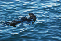
Plan to spend at least two hours in the aquarium and much longer if you are especially fascinated by the ocean. Also, check the feeding times for the otters in the otter tank, one of the most popular of the attractions. Additional programs are shown in the outside viewing areas and in the aquarium’s theaters.
Directions: From Monterey’s wharf area take Del Monte Avenue west through the tunnel. Here, Del Monte turns into Lighthouse Avenue. Take the first right turn onto Foam Street and follow it several blocks until it ends. Turn right at the traffic light. The aquarium is very visible a block down the hill at 886 Cannery Row.
Activities: Special talks and movies. Periodic special evening events for members.
Facilities: Gift shops, restaurant and snack bar, outside seating and viewing areas.
Dates: Open daily 10 to 5. Extended hours during summer.
Fees: There is a moderate entrance fee charged for adults and a lesser fee for children.
During summer weekends the line to enter can stretch up the street quite a distance.
For more information: Monterey Bay Aquarium, 886 Cannery Row, Monterey, CA 93940. Phone (831) 648-4800.
Copyright 2015 by Publishing Syndicate, all rights reserved.
For permission to reprint text or photos contact Ken@PublishingSyndicate.com

w202
Monterey Bay
National Marine Sanctuary
Established in 1992, the Monterey Bay National Marine Sanctuary encompasses 5,322 square miles of ocean, making it the country’s largest marine sanctuary. It also has the distinction of claiming 276 miles of the nation’s most beautiful and rugged shoreline. Ocean researchers come from around the world to conduct research on the sanctuary’s rich underwater resources, which include not only the plants, geologic features, and the strange creatures found in depths that reach 2 miles, but also the extensive kelp beds that stretch along its entire length.
The sanctuary is operated by the National Oceanic and Atmospheric Administration (NOAA: pronounced Noah). NOAA and numerous research institutes are committed to continuing research and education. Knowing what effects changing water temperatures will have on phytoplankton, the marine food chain’s base organism, and what effect those changes can have on the other animals can help scientists make decisions about how to manage marine mammals or what marine resource protections might be added to or reduced.
The sanctuary stretches from Rocky Point, 7 miles north of the Golden Gate to Cambria Rock in San Luis Obispo County. While not prohibiting such things as commercial fishing, the sanctuary’s status still provides significant protection for its 26 species of marine mammals, 94 species of seabirds, and 345 fish species. There are also 4 turtle species, 31 phyla of invertebrates, and more than 450 species of marine algae, kelp being one of the most predominant.
For more information: NOAA, 320 Foam Street, Suite D, Monterey, CA 93940. Phone (831) 647-4201.
Copyright 2015 by Publishing Syndicate, all rights reserved.
For permission to reprint text or photos contact Ken@PublishingSyndicate.com
w203
Monterey Bay
Recreation Trail
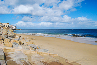
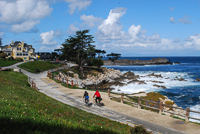
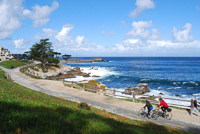
Beginning at Pacific Grove’s Lovers Point, a paved and relatively level recreation trail meanders with the give-and-take of the shoreline. Following a historic and abandoned railroad right-of-way, it passes the Monterey Bay Aquarium and through the middle of the Cannery Row area. If you happen to be around Cannery Row without a bike, there are several rental shops along the trail, which goes on to San Carlos Park, which is next to the Coast Guard pier and is also a favorite gathering and preparation area for scuba divers. The trail next swings in around the harbor and passes between Fisherman’s Wharf and the historic Custom House, and around behind the Maritime Museum of Monterey. It parallels Monterey State Beach and Seaside State Beach and soon takes a weird twist over the freeway, behind a shopping center, then back to the beach in Sand City and Seaside. Following between the railroad tracks and Highway 1 (freeway) it heads on to the town of Marina, in all more than 12 miles. Through Pacific Grove and Monterey the trail is very level. After passing Seaside State Beach it begins a series of ups and downs as it passes over and down freeway overpasses, or beside them.
This is a very popular trail, overseen by several governmental jurisdictions. If speed is what you’re looking for, then staying away from the Pacific Grove/Cannery Row/Fisherman’s Wharf area should a priority during summer, unless you are biking or running very early in the morning in the fog. By the time the afternoon sun comes out, the trail is much too crowded for fast-peddling bicyclists. The trail is open to pedestrians and in-line skaters, although in some areas pedestrians are directed by signs to walk on the dirt walkway adjacent to the paved trail, while bicyclists and in-line skaters use the paved trail. Pedestrians don’t always do so. The trail is not lighted for night use.
Directions: The best place to park and unload bicycles is either at Lover’s Point Park parking lot in Pacific Grove or in the parking lot just off Del Monte Avenue, just east of Sloat Avenue and across the street from the gate into the Naval Post Graduate School. The Fisherman’s Wharf parking lot off Del Monte Avenue also offers easy access to the recreation trail.
Activities: The bike trail is open to walkers, runners, bicyclists, and in-line skaters. Skateboards are prohibited.
Facilities: Except at Lovers Point and Fisherman’s Wharf, there are no stand-alone restrooms along the trail.
Dates: The trail is open daily.
For more information: Monterey Peninsula Visitor and Convention Bureau inside the Stanton Center/Maritime Museum of Monterey on Custom House Plaza. Phone (831) 649-1770.
Copyright 2015 by Publishing Syndicate, all rights reserved.
For permission to reprint text or photos contact Ken@PublishingSyndicate.com

w204
Monterey Peninsula
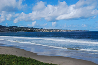
While the younger, wilder, college set tends to favor Santa Cruz, just across the bay, the Monterey Peninsula brings the more mellow and slightly older generation who can better afford more expensive hotels, restaurants, and golf courses. Of course, there are many reasonably priced places to stay and eat, but you have to look. Daytime temperatures are generally a few degrees cooler on the Monterey side of the bay. The Monterey Peninsula includes the cities of Monterey, Pacific Grove, Carmel, and the gated community of Pebble Beach with its famous golf courses and Seventeen Mile Drive. Most people include Seaside and Marina in the list of Monterey Peninsula cities.
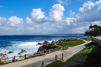
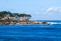
The Monterey Peninsula is known for many things, not the least of which are long sandy beaches and incredible tidepools. Beaches circle around from the mouth of the Salinas River, across land that once was part of the U.S. Army’s Fort Ord, now mostly abandoned. The beach portions will soon become a state park. Sand continues until the granite outcroppings begin to appear near Fisherman’s Wharf and continue around past the peninsula’s protruding point at Pacific Grove’s Point Pinos.
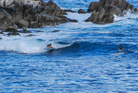
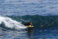
The waters of the bay are much too cold for swimming, although a few hardier souls, mostly youngsters, like to chase waves in a few of the more protected coves during summer and get wetter then they had originally planned. Surfers, clad in wet suits, have several favorite spots, depending on the direction and size of the waves. Lovers Point and Asilomar State Beach are two favorite surfing locations, especially during winter when the waves are big. For those less inclined to brave the cold waters, exploring the many rock-bound tidepools is a popular past-time. The entire area is part of either the National Marine Sanctuary, state parks, or marine preserve, so everything in the tidepools needs to be left where it is. Look at the sea stars and urchins, the sculpins and crabs, but don’t take them home. They won’t live, and they smell very bad when dead.
If you have a bicycle, bring it. There’s a great bicycle trail that runs from Lovers Point in Pacific Grove to Monterey’s Fisherman’s Wharf and is very level and very kid-accessible. Actually, the bike trail continues northeast around the bay another 10 miles or so to the town of Marina. It’s a nice ride, although there are several short, steep portions, as the trail must climb over several freeway overpasses.
Copyright 2015 by Publishing Syndicate, all rights reserved.
For permission to reprint text or photos contact Ken@PublishingSyndicate.com
w205
Monterey
State Historic Park
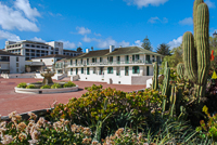
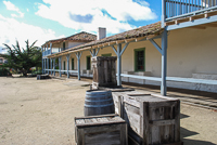
Monterey is the second oldest city in California, founded in 1770. San Diego is just a year older, but it was Monterey that served as Spain’s and then Mexico’s center of government for their respective California empires. Monterey was also the center for trade, and for many years the only customhouse was located here on the shore of the bay. The Custom House, like most of Monterey’s eighteenth and nineteenth century buildings, was constructed of adobe bricks, molded from a combination of clay and straw, dried, then stacked into walls, and finally covered with plaster to protect them from the rain.
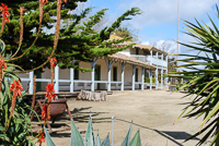
Unlike most parks with obvious entrances, Monterey State Historic Park is a collection of adobe buildings spread throughout several blocks of old Monterey. There are two good places to begin tours of the historic park, and both are on Custom House Plaza, adjacent to the historic old Custom House and Fisherman’s Wharf. The first is at the Stanton Center, which houses the Maritime Museum of Monterey, the Monterey Peninsula Visitor Center, and the Monterey State Historic Park visitor center. A free orientation film in the Stanton Center Theater provides a quick overview of Monterey’s history and is the starting point for both guided and self-guided walking tours of the old city and its Path of History. Across Custom House Plaza from the Stanton Center is the historic Pacific House. Originally a government storage building during the 1800s, it now serves as a museum and orientation center for the state historic park.
Within Monterey State Historic Park there are several intriguing buildings that are musts to see. In 1879, Robert Louis Stevenson moved to Monterey, mostly living off the good graces of friends, since he had not yet become the famous writer that he would in the years that followed. The rooming house where he stayed has been restored, and many of his later possessions have been donated and are exhibited in what has become known as the Stevenson House. Nearby, the Cooper-Molera Adobe complex offers a look at a fully furnished adobe home with a beautiful gardens. Many of the historic homes in Monterey have beautiful gardens, and during summer docents lead special garden tours. Many of the historic adobes are featured on the different tours, as are city-owned historic buildings such as Colton Hall where California’s Constitution was written (in both English and Spanish) and signed in 1849.
Directions: Follow the signs on Highway 1, taking either the Del Monte Avenue or the Munras Avenue exits through town to the Fisherman’s Wharf parking lot. Custom House Plaza is the large, brick open area to the left on the short walk
between the parking lot and the wharf. The Stanton Center and Pacific House face one another on opposite sides of the plaza.
Activities: House and walking tours, periodic living history events, many weekend ethnic celebrations on the plaza during summer.
Facilities: In the area: bike trail, restaurants, museums, bookstores, historic houses.
Dates: Historic buildings and the Stanton Center are open daily except Thanksgiving, Christmas and New Year’s Day. Tour hours vary. The Pacific House is open daily from 9 to 5.
Fees: There’s a moderate fee for guided walking tours and house tours. Visitors may go on a free, self-guided walking tour by following the gold tiles in the walkways.
For more information: Contact the Monterey State Historic Park office at 20 Custom House Plaza, Monterey, CA 93940. Phone (831) 649-7118, or the Monterey Visitor and Convention Bureau, 380 Alvarado Street, Monterey, CA 93940, phone (831) 649-1770.
Copyright 2015 by Publishing Syndicate, all rights reserved.
For permission to reprint text or photos contact Ken@PublishingSyndicate.com
w206
Moss Landing
on Monterey Bay
About halfway around Monterey Bay, at the mouth of Elkhorn Slough, is the small fishing village of Moss Landing. The harbor is home to dozens of boats, both pleasure and commercial fishing vessels. The small, quaint community is mostly an interesting collection of antique shops that are always fun to wander through and explore. But what most people, especially Monterey Peninsula locals, come here for is the food. Two restaurants stand out as great places to eat, not only for the good food, but also for their reasonable prices. The first, The Whole Enchilada (phone 831-633-3038, inexpensive), is an interesting pink building right off Highway 1 at the
intersection of Moss Landing Road. As the name implies, great Mexican food is its specialty and the prices are remarkably reasonable.
For a very different kind of eating experience, continue on Moss Landing Road a very short block, and turn right onto Sand Holdt Road. The narrow two-lane road crosses an even narrower one-lane bridge, which can be a bit of a challenge to get over, although hundreds of cars make the trip daily. Generally, rather than alternating one car at a time when crossing, the several cars that may be backed up go across, while those on the opposite side simply wait until there’s a break and they can go in a group. The bridge is scheduled for widening in the future, so you may not experience the minor delay getting across.
Once across, it’s even more obvious that this is a working, commercial fishing harbor. Drying nets and other fishing-related equipment line the narrow roadway. The new building on the left is the home of the Monterey Bay Aquarium Research Institute (MBARI). While inquiring minds can wander into MBARI’s headquarters and get an overview of the institute’s mission and goals, the old run-down-looking building next door is a must-see.
Phil’s Fish Market (phone 831-633-8611, inexpensive) from the outside, appears to be an old fish-processing warehouse and not much more. Park wherever you can find a spot, along the road or behind the market, then wander inside. Senses can be overwhelmed, so just enjoy the sights and sounds. In the center of the small room with its old wood walls and wet concrete floor, there is a large, open table of crushed ice, covered with whole fresh fish—salmon, halibut, rock cod, or whatever’s been caught—along with a variety of shellfish, including clams, oysters, and mussels. Some employees clean fish in the open, while others are behind counters cooking. There’s also a refrigerated glass case filled with fish filets and steaks. A small side room, nearly always crowded, is where the line forms to place lunch or dinner food orders. There’s an extensive menu, featuring mostly fish, including the day’s specials scribbled on the erasable menu wallboards. Find a seat at one of the inside or outside tables, sometimes a challenge on summer weekends, and your food will soon be delivered. Afterward, take a walk on the beach, which is just behind Phil’s.
Directions: From Highway 1 at Moss Landing, turn onto Moss Landing Road.
Activities: Dining, fishing, beachcombing.
Facilities: Boat rental, restaurants.
Dates: Open daily.
For more information: Fishing charters are available through Tom’s Sport Fishing on a 50-foot boat. Phone (831) 633-2564.
Copyright 2015 by Publishing Syndicate, all rights reserved.
For permission to reprint text or photos contact Ken@PublishingSyndicate.com
w207
Pacific Grove
Museum of Natural History
This is one of those hidden treasures that will remain undiscovered, unless you happen to be traveling slightly off the main tourist route of popular Lighthouse Avenue. Outside the museum is a concrete replica of a gray whale, which kids can’t help but climb on. Sometimes the tough part is getting them inside. But once inside, anyone interested in the Central Coast natural history is in for a surprise. All those birds, from avocets and western sandpipers, to willits and brown pelicans, that inhabit the coastal shore and are difficult to identify using a bird book, are waiting inside a large glass exhibit case. Unfortunately they’ve been stuffed, but at least they don’t move and their names are printed neatly next to them.
Additional exhibits on geology, mammals, insects, and more fill the small museum. And for those who drop in occasionally, there is always a major exhibit in the museum’s large exhibit hall. Special guest lectures are also a feature. It’s a good place to spend time becoming oriented to the area’s diverse natural history.
Directions: From Pacific Grove’s Lighthouse Avenue in the central business district, drive down toward the Bay 1 block to Central Avenue, which parallels Lighthouse Avenue. The museum is at the corner of Forest and Central avenues.
Activities: Lectures, occasional children’s programs.
Facilities: Natural history exhibits, small gift shop.
Dates: Open daily except Mondays. Closed Thanksgiving, Christmas, and New Year’s Day.
Fees: None.
For more information: Pacific Grove Museum of Natural History, 165 Forest Avenue, Pacific Grove, CA 93950. Phone (831) 648-3116.
Copyright 2015 by Publishing Syndicate, all rights reserved.
For permission to reprint text or photos contact Ken@PublishingSyndicate.com

w208
Pacific Grove
The self-proclaimed “Last Hometown” is a quaint and beautiful small town that sits on the point of land that separates Monterey Bay from the open waters of the Pacific Ocean. Generally draped in fog during summer, while its neighbor Monterey enjoys afternoon sunshine, Pacific Grove’s main street, Lighthouse Avenue, provides a short few blocks of wonderful antique shops, restaurants, the Scottish Bakery (which is a local favorite), a bookstore, and more. During the Christmas season, the trees and buildings are brilliantly illuminated in white and multicolored lights.
From where it begins near the Monterey Bay Aquarium, Pacific Grove’s Ocean View Boulevard meanders along the coast, adjacent to the Monterey Bay Recreation Trail, to Lovers Point. Continue on Ocean View Boulevard where several parking areas on the low, coastal bluff offer great opportunities to explore the rocky tidepools that the town is so well known for. Near Point Pinos the same road turns into Sunset Avenue and continues around the point.
Look closely at many of Pacific Grove’s older Victorian and smaller, more quaint homes, and notice many have small wood plaques near their doors indicating the late nineteenth and early twentieth century dates of their construction. Pacific Grove was founded as a Christian retreat. And indeed, Pacific Grove’s Asilomar State Beach and Conference Grounds was constructed in 1914 as a Young Women’s Christian Association (YWCA) summer camp. Many of its original buildings were designed by Julia Morgan, the renowned California architect who designed Hearst Castle. Today, Asilomar is a world-renowned conference center owned by California State Parks. Asilomar also accepts non-conference guests in its moderately priced accommodations.
Asilomar State Beach easily is the peninsula’s most popular spot for sunset watching. While summer’s fog often obscures the sun behind a thick gray curtain, during the rest of the year cars begin parking along the road an hour or more before sunset in order to guarantee the perfect viewing spot. Here, the open ocean’s crashing waves, especially during winter, offer ample opportunities for great memories and beautiful photographs.
Sunset Avenue circles around Pacific Grove crossing Seventeen Mile Drive, which offers access to one of several gates into Pebble Beach. Actually, Seventeen Mile Drive begins (or ends) in Pacific Grove, crossing Lighthouse Avenue a few blocks west of the town’s business district.
One of the favorite trips for bicyclists in Pacific Grove is the Sunset Drive to Ocean View Avenue coastal route. While Ocean View is reasonably level with gentle hills, Sunset Drive has a fairly long and steep descent from well above its beginning at Highway 68, just above Seventeen Mile Drive. There is also lots of traffic, most of which travels slowly, which is good; but be aware that most drivers are looking at the ocean and not for bicyclists.
Directions: From Highway 1 heading south from Monterey to Carmel, take the Highway 68 Exit to Pacific Grove, Pebble Beach and Asilomar. Turn right onto Highway 68 at the freeway overpass traffic light and continue on to Pacific Grove. Continue on Highway 68 through the commercial part of the town’s two traffic lights. Highway 68 turns left and becomes Sunset Drive. Drive about 1 mile more to Asilomar State Beach and Conference Grounds at the bottom of the hill, along the coast.
For more information: Asilomar State Beach and Conference Grounds, 800 Asilomar Avenue, Pacific Grove, CA 93950. Phone (831) 372-8016 or (831) 372-4076. For additional information contact the Monterey Peninsula Visitor and Convention Bureau, phone (831) 648-5358.
Copyright 2015 by Publishing Syndicate, all rights reserved.
For permission to reprint text or photos contact Ken@PublishingSyndicate.com
w209
Pebble Beach &
Seventeen Mile Drive
A must-do tour while on the Monterey Peninsula is the famous Seventeen Mile Drive that meanders through Pebble Beach. The original Seventeen Mile Drive began in Monterey, from the Victorian-style Hotel Del Monte, which, when constructed in 1880, was the “Queen of American Watering Places” and considered the most elegant seaside resort in the world. Fire destroyed the original hotel, but another was rebuilt. The replacement structure may be seen on the original hotel’s site at today’s Naval Post Graduate School headquarters in Monterey. The original tours from the hotel used horse-drawn wagons; today’s tours begin at the private gates into Pebble Beach, with visitors using their own cars or bicycles.
Pebble Beach evolved from properties, including the coastline and the Del Monte Forest, originally consolidated into Del Monte Properties by railroad magnate Charles Crocker. Crocker began developing portions of the property, including a beach bathhouse and a racetrack, but the economics of the time took a downturn. Subsequently a young Samuel F. B. Morse, a very, very distant relative of Samuel F. B. Morse, best known for his invention of the telegraph, and a group of investors purchased the property in 1915. Soon afterward, Morse began developing Pebble Beach into what it is today.
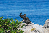
While today’s tours may not total the full 17 miles, the views remain as memorable as those seen by visitors a century ago. From the Pacific Grove gate into Pebble Beach, Seventeen Mile Drive leads past the Inn at Spanish Bay and down to Spanish Bay where many people come for the long, sandy beach. The tour road continues weaving between the Spanish Bay golf links. There almost always is a large population of feeding deer on the fairways. There are several popular stops along this stretch of Seventeen Mile Drive, including Point Joe, where the ocean’s currents cross paths with currents from Monterey Bay, creating constantly crashing waves and ocean mist just offshore. The sounds of barking sea lions coming from Bird Rock, also favorite resting place for seabirds, can easily be heard over the ocean waves. China Rock memorializes the Chinese who established fishing villages, not only here, but in other areas between Monterey and Point Lobos. Wind your way up to Cypress Point Lookout, and on clear days Point Sur lighthouse, located 20 miles down the Big Sur coast, is visible.
Why has Seventeen Mile Drive remained so popular for so long? It certainly has something to do with the spectacular views of the coast. There are also the incredible homes tucked into the coastal cliffs and partially hidden in the Del Monte Forest, homes with prices that generally fall into the seven- and eight-figure range. If traffic and crowds are any gauge, the most popular site along Seventeen Mile Drive is the famed Lone Cypress that is perched rather precariously near the end of a rocky point surrounded by the swirling surf. The Lone Cypress is estimated to be somewhere between 200 and 300 years old, which is remarkable considering its extremely inhospitable home, surrounded by sea, wind, and non-fertile rock.
Traffic, especially on summer weekends, can become a bit snarled, so an alternative to fighting it is to make your way to the vicinity of the Lodge at Pebble Beach and drop into the Tap Room Bar & Grill. It’s always a fun place to be, the food’s great, and the food is moderately priced. It’s also a place where many of golfing and Hollywood stars drop in during the AT&T ProAm. Reservations are always a good idea. Phone (831) 625-8535.
Seventeen Mile Drive is a popular place for bicycle touring, but this is not a place for beginning or infrequent riders. There are several steep hills, and often there isn’t much space between passing cars and bicyclists. Also, some parts of Pebble Beach are off limits to bicyclists. But, otherwise, a good place to enter is through the Pacific Grove gate. Bicyclists must sign in. Actually, cyclists sign a waiver of liability form that includes a map of the bicycle route along with permitted routes of travel.
Directions: There are actually several entry gates to Pebble Beach and Seventeen Mile Drive. The two most popular are the Pacific Grove Gate near the intersection of Highway 68 (Sunset Drive) and Seventeen Mile Drive. This entrance is closest to Spanish Bay and farthest from the Lodge at Pebble Beach. The other popular entrance is just off Highway 1 at the Highway 68 Exit, between Monterey and Carmel. From this entrance, the Lodge at Pebble Beach (expensive) is a short, five-minute drive away.
Activities: Scenic driving with numerous stops, golf, beach walking, horseback riding, picnicking, fine dining.
Facilities: Hotels, restaurants, golf courses.
Dates: Open daily.
Fees: There is a small fee for nonresident vehicles to enter Pebble Beach and Seventeen Mile Drive. Bicyclists must sign the release form located near the entry gate and enter at no cost. Hotels, most restaurants, and golf courses are expensive.
Closest town: Carmel and Pacific Grove are adjacent to Pebble Beach.
For more information: The Lodge at Pebble Beach, PO Box 1128, Pebble Beach, CA 93953. Phone (831) 624-3811.
Copyright 2015 by Publishing Syndicate, all rights reserved.
For permission to reprint text or photos contact Ken@PublishingSyndicate.com
w210
Pfeiffer Beach
Big Sur
Most of Los Padres National Forest is located on the inland side of Highway 1, but there are several areas within its boundaries where access to the Pacific Ocean is possible. About 0.25 mile south of the Big Sur Station, a narrow, barely marked road turns off Highway 1 and leads through Sycamore Canyon to Pfeiffer Beach. It’s easy to miss the turn-off and once on the road to the beach, meeting a motorhome creates problems on the mostly one-lane road. During summer weekends, the parking lot will generally fill and if all goes well, someone will place the “full” sign at Highway 1 as a warning not to attempt the drive.
Directions: The access road is located about 0.5 mile south of the entrance to Pfeiffer Big Sur State Park, on the ocean side off Highway 1.
Activities: Picnicking, beachcombing, fishing.
Facilities: None.
Dates: Open daily, however, on summer weekends the parking lot can fill early, so access could be limited.
Fees: There is a small day-use fee.
For more information: U.S. Forest Service Office in Goleta, phone (831) 683-6711, the King City office, phone (831) 385-5434, or the Big Sur Station, phone (831) 667-2315.
Copyright 2015 by Publishing Syndicate, all rights reserved.
For permission to reprint text or photos contact Ken@PublishingSyndicate.com
Publishing Syndicate
PO Box 607 Orangevale CA 95662
Ken@PublishingSyndicate.com
Copyright 2010-2016 by Publishing Syndicate: All rights reserved