
w211
Pfeiffer Big Sur
State Park
If you spend much time wandering along the Big Sur River, through the redwood groves, or along the trails to the park’s mountain promontories, it becomes immediately apparent why the early settlers fell in love with this land. Michael Pfeiffer and his wife Mary became the first European settlers in the area when they built their home in nearby Sycamore Canyon in 1869. To make a living, they cut redwood trees for lumber, farmed the land, and kept bees that feasted on the flower-covered hillsides, making plenty of honey. Their son John homesteaded a 160-acre parcel near the Big Sur River and moved to where the historic Homestead Cabin is located today.
By the turn of the century, Big Sur’s redwoods and its rugged coast were drawing the more adventurous hunters and fishermen who were willing to travel the rugged coastal trail from Monterey. Seeing an opportunity for additional income, John Pfeiffer’s wife Florence started Pfeiffer’s Ranch Resort, built where today’s Big Sur Lodge is located. During those early years, the Pfeiffers operated a small lumber mill in addition to several private guest cabins. In 1933, John Pfeiffer sold 680 acres to the California State Park System. That original acreage, plus another 300-plus acres that have been acquired over the years, is now Pfeiffer Big Sur State Park.
Even though the park lies near the southernmost limit of the coast redwoods range, and most of its old-growth trees were cut during the Pfeiffers’ ownership, the groves that remain are quite impressive. The park’s largest tree is located near the group picnic area. Named the “Colonial Tree,” it measures 27 feet in circumference. Not far from the lodge a grove of 800- to 1,200-year-old redwoods make up the “Proboscis Grove.”
Most of the redwoods grow on the flat that follows the Big Sur River as it runs the length of the park. Sycamores (Platanus racemosa), willows (Salix spp.), black cottonwoods (Populus trichocarpa), and alders (Alnus spp.) create a thick forest of riparian growth, which in turn provides food and homes for dozens of animal species. Hiking up one of the trails, the moist riparian vegetation quickly changes to species better adapted to handle the hot, dry summers on the mountainsides, especially along the south-facing slopes. In many places the chaparral plants grow so densely that going off trail is nearly impossible. Chamise (Adenostoma fasciculatum), toyon (Heteromeles arbutifolia), manzanita (Arctostaphylos spp.), California coffeeberry (Rhamnus californica), and ceanothus (Ceanothus spp.) are some of the most common chaparral shrubs.
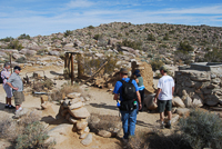
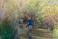
Pfeiffer Big Sur State Park is easily the most popular park in the Big Sur area. Its large campground is full all summer, mostly with families and the sounds of kids having fun. The Big Sur River is the main attraction, with people swimming or wading, especially during the warmest days. There’s a trail that meanders up the north side of the river, officially ending perhaps 0.25 mile upriver from the Whalen bridge. From there, most people continue, sometimes scrambling over the rocks, sometimes wading in the river or swimming across the small, deeper pools, exploring an area called the “Narrows.”
Directions: The park entrance is located about 26 miles south of Carmel on the east side of Highway 1.
Activities: Camping, hiking, picnicking, softball, nature study.
Facilities: The park has two group camps, each with a 35 person capacity and 215 developed campsites, but none with RV hook-ups. Since riding the coast on bicycles is such a popular way to experience Big Sur there are 10 bicycle environmental campsites. Camping reservations are almost always required during summer and spring holiday weekends. Phone (800) 444-7275. The Big Sur Lodge offers cabins, some with kitchens. There’s also a swimming pool for lodge guests. Phone (831) 667-2171 for lodge information and reservations.
Dates: The park is open daily.
Fees: Both day-use and camping fees are collected in the park
Closest town: The local Big Sur community has minimal services. The nearest major community is Carmel, 26 miles north on Highway 1.
For more information: Contact the Big Sur Station, 0.25 mile south of Pfeiffer Big Sur State Park. Phone (831) 667-2315.
Copyright 2015 by Publishing Syndicate, all rights reserved.
For permission to reprint text or photos contact Ken@PublishingSyndicate.com
w212
Point Lobos
State Reserve
Point Lobos is one of those jewels that has attracted people since the earliest of times. Although permanent Native American villages were never possible because fresh water was not available year around, Indians did live along San Jose Creek, just a 0.5 mile or so to the northeast. Point Lobos has seen many changes during the past 150 years. It was used as a whaling processing site, an abalone processing and canning plant, and a shipping point for coal that was mined from the nearby mountains. At the end of the nineteenth century, the land was even subdivided by a developer who envisioned making a fortune selling homesites. Fortunately, with a combination of private donations and funds from Save-the-Redwoods League, the property became a state park in 1933.
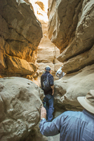
While the surface lands of Point Lobos may have been changed, at least superficially, by those wanting to exploit its natural resources, what hasn’t changed much in millions of years is the underlying geology. The relatively coarse-grained Santa Lucia Granite that formed deep below the surface some 110 million years ago was uplifted to form the jagged headlands along the reserve’s northern shore. Near the center of the reserve, from near Sea Lion Point, the Carmelo Formation, a sedimentary conglomerate, is most prevalent. Only 60 million years old, the more easily erodable conglomerate is composed of smaller stones in what appears as a yellowish-colored concrete. Throughout the reserve, the conglomerate has eroded to form jagged cliffs and graceful arches. Yet scattered in a few protected coves, several sandy beaches await exploration, while others remain inaccessible.
Besides the obvious terrestrial beauty, 750 underwater acres are also part of the reserve. Point Lobos is an incredibly popular scuba-diving spot, generally requiring reservations weeks in advance. One of the reasons it remains such a treasure for divers is that the number of divers is limited each day and everything is protected. Any spearfishing has to be done outside the reserve’s boundaries.
Many people first coming to the reserve are surprised by the numbers and varieties of wildlife that live in the reserve. The seemingly ubiquitous sea otters frolic in the cold waters and during spring and early summer they can be seen caring for their young offspring. The most vocally boisterous animals are the sea lions. Aptly named, Sea Lion Rock offers a small sanctuary from the crashing waves for large numbers of California sea lions (Zalophus californianus) at almost any time of the year. The adult males, which can weigh up to 800 pounds, leave the local waters during the first months of summer and swim to rookeries farther south. During the time of year when they are at Point Lobos in greater numbers, it is impossible to miss their loud, incessant barking or their antics on the offshore rocks. Their loud and persistent barking is what caused the early Spanish explorers to name the area Punta de los Lobos Marino: Point of the Sea Wolves.
Birds are another major attraction of Point Lobos. On almost any day, dozens of different species can be seen in the reserve. For Brandt’s cormorants (Phalacrocorax penicillatus) and black oystercatchers (Haematopus bachmani), western gulls (Larus occidentalis) and great blue herons (Ardea herodias), the sea, and the lands around it, provide rich feeding grounds. It’s not at all unusual, especially late in the afternoon, for deer to wander out into the open forest or meadows amidst grasses and wildflowers to graze, while coyotes and even more rarely, a mountain lion, cross the reserve’s several miles of trails.
In wind-protected Whalers’ Cove, there is a small wood cottage that has been around since the 1850s when Chinese fishermen and their families moved to Point Lobos. The museum houses numerous exhibits and whaling-era artifacts such as harpoons. A short walk down the road from the museum is where scuba divers park and enter the cove. There’s also a restroom and a picnic table or two. Over its history, the area occupied by today’s parking lot, has served as a whale rendering area, held an abalone cannery, and been home to a quarry that supposedly provided stone for part of the San Francisco Mint.
Directions: Point Lobos is 2 miles south of Carmel on Highway 1.
Activities: Hiking, bird-watching, whale watching, scuba diving, wildlife watching, museum touring, picnics in designated picnic areas only.
Facilities: Museum, trails, a small outdoor gift “cart.”
Dates: Opens daily at 9 to 7 during Pacific daylight time and closes at 5 during Pacific standard time.
Fees: There is a fee for vehicles entering the reserve. Walk-ins are free.
Closest town: Carmel, 2 miles.
For more information: Point Lobos State Reserve, phone (831) 624-4909.
TRAILS
There are many trails that meander throughout the reserve, reaching headland promontories and secluded beaches. There are several coastal areas where scrambling among the rocks and cliffs, which can’t be harmed by the hundreds of thousands of people who visit Point Lobos each year, is allowed. But generally, because of the extra level of protection afforded the reserve, hikers are restricted to the trails where they wind through the forests and grasslands. In many areas it’s also in the best interest of hikers, because poison oak thrives throughout the Central Coast, including at Point Lobos.
The North Shore Trail [Fig. 44(1)] begins at Whalers’ Cove and immediately heads uphill. Spring and summer wildflowers highlight the trail and deer are not uncommon sights. The jagged cliffs of the shoreline and the small, nearshore islands are homes to numerous nesting birds, including cormorants (Phalacrocorax spp.), western gulls (Larus occidentalis), and pigeon guillemots (Cepphus columba). The trail winds for 1.4 miles through the forest and ends at the Information Station at the Sea Lion Point parking lot.
The Sea Lion Point Trail [Fig. 44(2)] begins at the Sea Lion Point parking lot and is just over 0.5 mile long. It ends in an open bluff area that offers a great look at a part of the park’s geology. The pounding waves and rain have sculpted the 60-million-year-old Carmelo Formation conglomerate into wonderful shapes. Harbor seals (Phoca vitulina) often lie balanced and sleeping on some of the smaller rocks just offshore, while barking California sea lions generally cover the large rock known as Sea Lion Rock, farther offshore. Between shore and Sea Lion Rock, an area called Devil’s Cauldron turns the approaching ocean waves into crashing, churning, spectacular white geysers of water.
Bird Island Trail begins at the far southern parking lot and passes through the coastal scrub, finally ending on a bluff that overlooks Bird Island. On the way, the trail passes two sandy beaches that can be reached by staircases. While birds abound and otters play in the kelp just offshore, it is the hundreds of Brandt’s cormorants (Phalacrocorax penicillatus) that cover Bird Island during spring and summer that make this short hike unforgettable.
Copyright 2015 by Publishing Syndicate, all rights reserved.
For permission to reprint text or photos contact Ken@PublishingSyndicate.com
w213
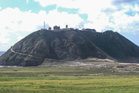
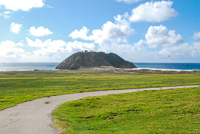
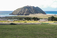
Point Sur
State Historic Park
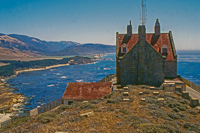
California’s coast was a dilemma for the maritime traders who followed in the footsteps of the early European explorers. Fog, jagged offshore rocks, jutting headlands, unpredictable winds, surging tides, and storm-driven waves caused many captains to lose their ships, their cargoes, and their lives. As maritime shipping became more common along California’s coast, the number of lighthouses slowly increased. The Point Sur lighthouse was first lit in the summer of 1889. The light actually sits lower than the top of the Rock, as its rock promontory is referred to, placed so that it would shine below where the fog most often settled.
For most Big Sur coast travelers, Point Sur is easily one of the most prominent landmarks they pass. The Rock juts up nearly 400 feet above the long, shoreline beach. The light was originally a first order Fresnel lens that could be seen from 23 miles out to sea. While the lens certainly aided navigation safety, it didn’t insure that ships and rocks still wouldn’t meet. The Los Angeles was lost in 1894, the Majestic in 1909, and several more vessels, including the Howard Olson in 1956, went down near Point Sur. Each time a ship broke apart, its cargo was scattered along the coast bringing out the locals who were quite happy to help clean up the beaches.
Perhaps the most famous shipwreck near the Rock was the crash of the USS Macon, a helium-filled rigid airship that went down on February 12, 1935. The 785-foot-long, lighter-than-air ship served as a flying aircraft carrier, able to launch and retrieve small, single-engine airplanes. The Macon crashed into the Pacific with its 83 crew members, all of whom survived but two. The small visitor center at the top of the Rock includes exhibits on the Macon.
Today, while the Coast Guard still maintains an automated light at Point Sur, the remainder of the Rock is part of Point Sur State Historic Park. Several buildings are part of the light station, including a barn, blacksmith shop, two-story head keeper’s house, and the triplex where three assistant keepers and their families lived. There is an ongoing restoration program.
Directions: Point Sur State Historic Park is located about 19 miles south of Carmel on Highway 1. The entrance is at a farm gate adjacent to Highway 1, about 0.25 mile north of the abandoned Point Sur Naval Facility, a casualty of the Cold War’s end. There are plans to use the Naval Facility as a visitor center in the future.
Activities: Tours of the lighthouse, headkeeper’s house, the small museum, and other buildings as they are restored. This is a great winter whale-watching site during winter tours.
Facilities: Visitor center and small gift shop.
Dates: Tours are held on a first-come first-served basis and take about two hours.
Participants are required to walk to the top of the Rock as parking is limited and private vehicles are not allowed to drive up the steep, narrow road. Docents lead tours on weekends and during midweek. Tour times and days may change, so call ahead. A warning: Occasionally there are warm, sunny, beautiful days on the “Rock.” But most often it is cold and extremely windy, not to mention foggy. Wear, or at least bring, several layers of clothing, even during summer.
Fees: There is small tour fee.
Closest town: Carmel, 19 miles north.
For more information: The park is not staffed. Call the park’s automated information phone at (831) 667-0528. During winter it’s always a good idea to call because tours will be canceled if rain is likely. Additional information can be obtained during normal business hours by contacting the Monterey District State Park Office, 2211 Garden Road, Monterey, CA 92940. Phone (831) 649-2836.
Copyright 2015 by Publishing Syndicate, all rights reserved.
For permission to reprint text or photos contact Ken@PublishingSyndicate.com
w214
Santa Cruz
What began as home for the Ohlone Indians and was changed into a mission by the Spanish has been transformed into a summer recreation hot spot, mostly for tens of thousands of San Francisco Bay and Central Valley residents each year. Seems folks living in San Francisco are searching for a slightly less foggy and warmer weekend getaway and those living in the Central Valley are looking for an escape from summer’s too often 100-plus degrees Fahrenheit days.
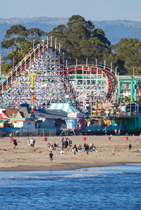
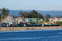
THE SANTA CRUZ BEACH BOARDWALK
The colorful and popular boardwalk is one of those places that kids of all ages enjoy. It’s loaded with the kinds of fun food that most people probably shouldn’t eat more than once or twice a year, and stomach-wrenching roller coaster thrills that can make most people wish that food hadn’t been a first priority upon arrival. The boardwalk stretches for nearly 1 mile right at the edge of the city’s main beach, itself a vast stretch of sand that attracts thousands of people on warm summer days. The boardwalk itself can be just as crowded as the beach on weekends and lines can be long for some of the more popular rides carrying such ominous names as Tsunami, Crazy Surf, and Whirlwind. For a great overview of what’s here, there’s a monorail that circles around and above the boardwalk at a leisurely pace. For those interested in nostalgia, the traditional wooden roller coaster that was built in 1924 remains one of the best in the country. The Giant Dipper has been updated over the years, but the views of the bay and the screams that accompany 55-m.p.h. speeds are a must. For those with weaker stomachs, or parents with smaller kids, there is the equally classic Looff Carousel. With its 73 carved horses and its late nineteenth century, 342-pipe band organ, it has thrilled 50 million people since 1911.
Directions: From Highway 1, take the Ocean Street Exit and follow Ocean Street toward the bay to its end at the wharf area. Turn left and drive the four blocks to 400 Beach Street.
Facilities: Rides, games, food.
Dates: Open daily from Memorial Day to Labor Day, then weekends and holidays the remainder of the year; hours also vary by season.
Fees: The boardwalk is free, but there is a fee for the rides.
For more information: Santa Cruz Beach Boardwalk, 400 Beach Street, Santa Cruz, CA 95060. Phone (831) 423-5590.
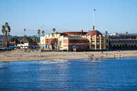
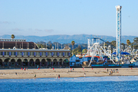
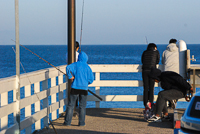
SANTA CRUZ MUNICIPAL WHARF
Wharves everywhere seem to attract people. The Santa Cruz Municipal Wharf is no exception, and it has the added attraction of being the longest wharf on the West Coast. It’s also a place loaded with shops and restaurants, and fishing can be remarkably good from the wharf if you’d prefer to catch your own. Halibut, striped bass, jacksmelt, and surf perch aren’t opposed to taking live bait. The more adventurous can rent wooden skiffs with small outboard motors and head out a bit farther to the offshore rocky reefs where rockfish and larger lincod are occasionally hooked.
Directions: From Highway 1 in Santa Cruz, take the Ocean Street Exit and drive toward the bay where Ocean ends at Beach Street and the wharf.
Activities: Dining, fishing, shopping,
Facilities: Restaurants, bait shop, gift shops, boat and kayak rentals.
Dates: Open daily.
Fees: There is a fee for vehicles. No fee for pedestrians.
For more information: Santa Cruz County Conference & Visitors Council, 701 Front Street, Santa Cruz, CA 95060. Phone (800) 833-3494 or (831) 425-1234.
SANTA CRUZ SIDE TRIPS
Drive the roads (West Cliff Drive and Beach Street) that follow the cliffs along the city of Santa Cruz area and numerous surprises await. Natural Bridges State Beach (phone 831-423-4609), is north of the main part of town, at the end of West Cliff Drive and has a great beach. It gets its name from the offshore rocks, although the longest wave-carved rockbridge collapsed years ago. The park’s eucalyptus grove hosts thousands of wintering monarch butterflies.
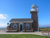
The Santa Cruz Mission’s original site is located above the beaches and cliffs at the intersection of High and Emmet streets. The mission was founded in 1791, but an 1857 earthquake destroyed much of the original building. A smaller replica was constructed in 1931 on Emmet Street. The Lighthouse Field State Beach and Surfing Museum
Copyright 2015 by Publishing Syndicate, all rights reserved.
For permission to reprint text or photos contact Ken@PublishingSyndicate.com
w215
Nationial
Steinbeck Center
Salinas
Salinas, about 20 minutes from Monterey, was the birthplace of John Steinbeck, whose many novels and short stories have entertained millions of people. His Pulitzer Prize-winning novel, The Grapes of Wrath, also angered many of those who lived and worked in the Salinas Valley. Apparently Steinbeck hit a little too close to home with his descriptions of the lives of farm workers and how the farm owners treated them. Some of Steinbeck’s other books, such as Cannery Row and Tortilla Flat, brought to life some of the more colorful characters who lived and worked in 1930s Monterey.
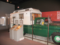
Today, Salinas is home to the National Steinbeck Center, a multimedia experience of the famous author’s life. Themed galleries feature exhibits related to his many novels and theaters show clips of the many films that were based on his writings. One of the center’s prized possessions is “Rocinante.” It’s the GMC pick-up truck with a custom camper that Steinbeck drove across the country while doing research for Travels with Charley. For the more academically inclined, the center houses over 30,000 pieces of oral histories, photographs, original manuscripts, and first edition books.
Directions: From the US 101 freeway as it passes through Salinas, take the Business US 101 Exit, which is also North Main Street and State Highway 183. The Center is about 0.25 mile south of US 101 freeway. From Monterey, take Highway 68 (Monterey-Salinas Highway) north to Salinas. Highway 68 becomes Main Street once in Salinas, then turns to North Main. The center is located at 1 Main Street.
Facilities: Galleries, theater, gift shop.
Dates: Open daily. Closed Thanksgiving, Christmas, and New Year’s Day.
Fees: There is a moderate entrance fee with discounts for children and seniors.
For more information: The National Steinbeck Center, 1 Main Street, Salinas, CA 93901. Phone (831) 796-3833.
Copyright 2015 by Publishing Syndicate, all rights reserved.
For permission to reprint text or photos contact Ken@PublishingSyndicate.com
w216
Wilder Ranch
State Park
A great fertile crescent, beginning just north of Santa Cruz and wrapping around to the Monterey Peninsula, has served farmers and ranchers quite well since 1791 when the missions began farming here. Even today, the rich soil and mild climate allows such difficult-to-grow crops as artichokes and brussels sprouts to thrive. Although Wilder Ranch is now a state park, brussels sprouts and other crops are still grown on the surrounding lands near the ocean bluffs.
The entrance and parking lot are located just off the ocean side of Highway 1, and then it’s a short walk to the old Victorian farmhouse, the barns, and a small visitor center. A group of volunteers helps with the extensive flower and vegetable gardens, and maintains the farm animals that range from chickens to horses. A large shed shelters a wide assortment of antique farm implements and other equipment.
A dirt road through the complex crosses under Highway 1 and leads to a large corral area and an old (reconstructed) cowboy bunkhouse complex. The original bunkhouse was built by the Wilders for their ranch hands, but it served quite often as a gathering place for parties, and practices for the annual rodeos in which many of the area’s young cowboys competed. Much of the riding and roping activities stopped following World War II because accidents and their potential for lawsuits brought attorneys into the picture.
Beyond the bunkhouse a maze of dirt roads offers 42 miles of trails for hiking, horseback riding, and mountain biking. Being in shape certainly helps if a mountain bike is your chosen mode of outdoor transportation, because the trails get steep in a hurry. But once on top, the views of the Pacific Ocean on fogless days are spectacular. The mostly grassland hillsides are spotted with hidden ponds and rivers of green vegetation that meander their way down the gullies toward the ocean below.
Directions: Take Highway 1 north from Santa Cruz, about 1 mile past the traffic light at Western Drive. Signs along the highway are quite visible, but the park entry road, which cuts directly into a high roadcut on the ocean side, is a little more difficult to see until you’re nearly on top of it.
Activities: Hiking, mountain biking, picnicking, periodic living history events.
Facilities: Visitor center and a small gift shop, trails, farmhouse, barns, corral area and bunkhouse.
Dates: Open daily.
Fees: There is a day-use fee charged.
Closest town: Santa Cruz, 1 mile.
For more information: Santa Cruz Sector State Parks, 600 Ocean Street, Santa Cruz, CA 93960. Phone (831) 423-9703.
Copyright 2015 by Publishing Syndicate, all rights reserved.
For permission to reprint text or photos contact Ken@PublishingSyndicate.com
w217
xxx
A great fertile crescent, beginning just north of Santa Cruz and wrapping around to the Monterey Peninsula, has served farmers and ranchers quite well since 1791 when the missions began farming here. Even today, the rich soil and mild climate allows such difficult-to-grow crops as artichokes and brussels sprouts to thrive. Although Wilder Ranch is now a state park, brussels sprouts and other crops are still grown on the surrounding lands near the ocean bluffs.
The entrance and parking lot are located just off the ocean side of Highway 1, and then it’s a short walk to the old Victorian farmhouse, the barns, and a small visitor center. A group of volunteers helps with the extensive flower and vegetable gardens, and maintains the farm animals that range from chickens to horses. A large shed shelters a wide assortment of antique farm implements and other equipment.
A dirt road through the complex crosses under Highway 1 and leads to a large corral area and an old (reconstructed) cowboy bunkhouse complex. The original bunkhouse was built by the Wilders for their ranch hands, but it served quite often as a gathering place for parties, and practices for the annual rodeos in which many of the area’s young cowboys competed. Much of the riding and roping activities stopped following World War II because accidents and their potential for lawsuits brought attorneys into the picture.
Beyond the bunkhouse a maze of dirt roads offers 42 miles of trails for hiking, horseback riding, and mountain biking. Being in shape certainly helps if a mountain bike is your chosen mode of outdoor transportation, because the trails get steep in a hurry. But once on top, the views of the Pacific Ocean on fogless days are spectacular. The mostly grassland hillsides are spotted with hidden ponds and rivers of green vegetation that meander their way down the gullies toward the ocean below.
Directions: Take Highway 1 north from Santa Cruz, about 1 mile past the traffic light at Western Drive. Signs along the highway are quite visible, but the park entry road, which cuts directly into a high roadcut on the ocean side, is a little more difficult to see until you’re nearly on top of it.
Activities: Hiking, mountain biking, picnicking, periodic living history events.
Facilities: Visitor center and a small gift shop, trails, farmhouse, barns, corral area and bunkhouse.
Dates: Open daily.
Fees: There is a day-use fee charged.
Closest town: Santa Cruz, 1 mile.
For more information: Santa Cruz Sector State Parks, 600 Ocean Street, Santa Cruz, CA 93960. Phone (831) 423-9703.
Copyright 2015 by Publishing Syndicate, all rights reserved.
For permission to reprint text or photos contact Ken@PublishingSyndicate.com
w218
Anza-Borrego Desert
State Park
Copyright 2015 by Publishing Syndicate, all rights reserved.
For permission to reprint text or photos contact Ken@PublishingSyndicate.com
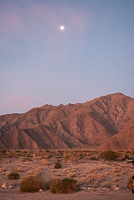
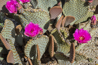
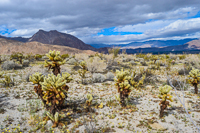
Story coming soon
w219
Seattle Air Museum
0 Ocean Street, Santa Cruz, CA 93960. Phone (831) 423-9703.
Copyright 2015 by Publishing Syndicate, all rights reserved.
For permission to reprint text or photos contact Ken@PublishingSyndicate.com


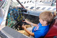

More photos and story coming!
w220
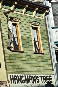
Hangtown
Placerville
600 Ocean Street, Santa Cruz, CA 93960. Phone (831) 423-9703.
Copyright 2015 by Publishing Syndicate, all rights reserved.
For permission to reprint text or photos contact Ken@PublishingSyndicate.com
More photos and story coming!
Publishing Syndicate
PO Box 607 Orangevale CA 95662
Ken@PublishingSyndicate.com
Copyright 2010-2016 by Publishing Syndicate: All rights reserved